- Details
- Hits: 7921
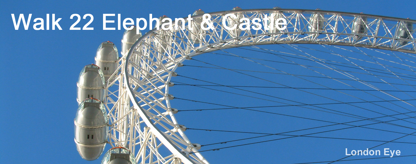
Walk 22 - From Elephant & Castle, at the Southern End of the Bakerloo Line, to Green Park Tube Station
|
Distance8 |
6 km (4 miles) |
|
Underfoot |
Paved throughout |
|
Outward Journey |
Bakerloo Line to Elephant & Castle About 10 minutes from Central London |
|
Return |
By Piccadilly or Jubilee Line from Green Park |
|
Points of Interest |
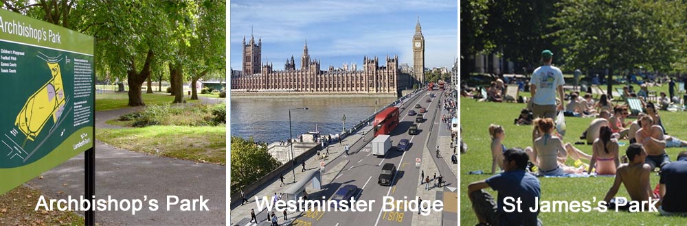
Imperial War Museum, Archbishops Park, Westminster Bridge, the London Eye, Houses of Parliament, St James's Park, Buckingham Palace |
|
Refreshments |
Tankard Pub in Brooke Drive, cafe in St James's Park, cafes in Piccadilly |
|
Public Toilets |
Archbishop's Park |
|
Shortening the Walk |
Finish at Westminster Underground Station. Several bus stops en route. |
What To Expect From This Walk
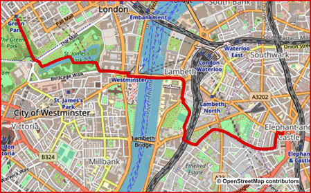
The walk starts from Elephant & Castle Underground Station and takes in many visitor attractions. From the Bakerloo Line exit at Elephant & Castle, you go down side streets to Archbishop's Park, one of the less well-known green spaces in Central London. You leave the park opposite St Thomas’ Hospital and soon cross Westminster Bridge, with the London Eye on your right and the Houses of Parliament ahead. After crossing Parliament Square, you come to St James's Park with its lake and wildfowl, including the famous pelicans. On the final section you pass close to Buckingham Palace before crossing Green Park to reach Piccadilly. The walk finishes at Green Park Underground Station.
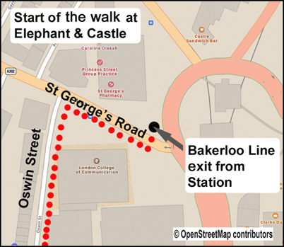
1. Leave Elephant & Castle Station via the exit from the Bakerloo Line and cross at the traffic lights directly in front of you to reach the other side of St George’s Road (the A302). Turn right along the foot-way and then take the first road left (Oswin Street). Walk to a junction and turn right into Brook Drive. Continue for 500m to the junction with Kennington Road. The Imperial War Museum is on your right and The Tankard pub on your left.
2. Cross Kennington Road at the lights. Go ahead through a gap between two blocks of flats and walk through a small parking area to reach a corner where a road comes in from the right and turns to go ahead. Your route is straight ahead on this road. Continue for about 400m, then turn right into Juxon Street, which brings you out onto Lambeth Road. Cross the road and go ahead into Archbishop’s Park.
3. You can walk left or right around the perimeter of the park. Your exit is at the far left-hand corner. If you choose the right-hand path you will pass the public toilets. As you leave the park you will see St Thomas’ Hospital over on the opposite side of the road. Cross the road, turn right and follow the footway to go left onto Westminster Bridge Road. You will see the Houses of Parliament ahead. When you reach the bridge, you will also see the London Eye to your right.
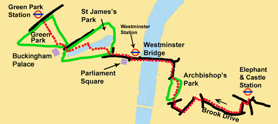
4. Cross over Westminster Bridge, past Westminster Underground Station, and continue in the same direction. The Houses of Parliament are to your left. Cross over to the right-hand footway and resume your direction by crossing at the lights at the lower end of Whitehall. Pass Parliament Square on your left. Go ahead into Great George Street, which leads to Birdcage Walk. St James’s Park is now on your right. Take the first entrance to the park. Walk down to the lake and turn left. Continue with the lake on your right until you reach a bridge.
5. Cross the bridge and turn left to continue with the lake now on your left. Just before you reach the end of the lake, turn right up a path. Leave St James’s Park and cross The Mall, with Buckingham Palace on your left. Enter Green Park and swing left around a curving wall. Turn right at the first major crossing path to walk uphill for about 450m to reach Green Park Station.
Information on Things You Will See
The London Eye on the Southbank is the world’s largest observation wheel and the most popular paid tourist attraction in the UK. Developed and constructed in Norway to mark the Millennium, the London Eye is the only cantilevered structure of its kind. The wheel was transported along the river on barges and lifted to its final position on 10 October 1999, but only after a failed attempt the day before. The 32 capsules of the Eye are symbolic of London’s 32 boroughs and are numbered 1 to 33 (eliminating the number thirteen!).
The Pelicans of St James’s Park were introduced to the park in 1664 as a gift from the Russian Ambassador. These large birds now form a colony which includes several Eastern Whites and at least one South American White. They are fed by park rangers between 14.30 and 15.00 daily. They are extremely sociable animals and have been known to leave the lake and sit on the benches beside office workers and tourists.
Buckingham Palace has served as the official London residence of British monarchs since 1837. Built by the Duke of Buckingham in 1703 as Buckingham House, it was purchased by George III in 1761 as a family home for his wife Queen Charlotte. The Palace consists of 775 rooms, including 19 State rooms, 52 royal and guest bedrooms, 188 staff bedrooms and 78 bathrooms. It is the administrative headquarters of the monarch and the Royal Standard is flown when the king or queen is present.
Big Ben is the nickname for the great bell of the clock at the north end of the Palace of Westminster. The tower is now officially known as the Elizabeth Tower having been renamed in honour of the Queen’s Diamond Jubilee Despite being one of the world's most famous tourist attractions, the interior of the tower is not open to visitors, though UK residents are able to arrange tours, well in advance, through their Member of Parliament. However, the tower has no lift. So, those escorted, must climb the 334 limestone stairs to the top.Due to changes in ground conditions since construction, the tower leans slightly to the north-west, by roughly 230 millimetres (9.1 in) over 55 m height, giving an inclination of approximately 1/240. Due to thermal effects it oscillates annually by a few millimetres east and west.


- Details
- Hits: 7721
Walk No 21 – From Aldgate at the Eastern End of the Metropolitan Line to Greenwich Cutty Sark Via Shadwell and Canary Wharf
|
Distance |
10 km (6 miles) |
|
Underfoot |
Paved throughout |
|
Outward Journey |
Metropolitan Line to Aldgate : About 10 minutes from Central London |
|
Return |
By DLR, train or river boat from Greenwich |
|
Points of Interest |
Tower of London, St Katherine Docks, Sprit Quay, Shadwell, Limehouse Basin, Canary Wharf, Mudchute, Maritime Greenwich |
|
Refreshments |
Cafes and pubs at several points along the walk |
|
Public Toilets |
Tower Hill (Trinity Gardens) and Canary Wharf |
|
Shortening the Walk |
Finsh at Canary Wharf after 6Km (DLR, Jubilee Line, boat to Central London) |
What To Expect From This Walk
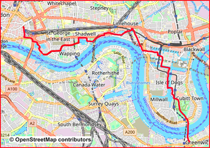
This walk is stuffed full of unique locations. It starts deep in the City of london at busy Aldgate Station and passes the Tower of London before diving under Tower Bridge Approach to reach St Katherine Dock. From there onwards, it leaves traditional tourist routes and goes via Spirit Quay and Shadwell Basin to reach the River Thames at King Edward VII Memorial Park where, at the time of writing, walkers will see the huge engineering project to build London's new super sewer. A short stretch of the Thames Path brings us to attractive Limehouse basin with its picturesque boats and barges. It is then a short walk to Canary Wharf with its super-modern architecture. The unique geography of Canary Wharf on the Isle of Dogs can be confusing; so please follow the route instructions. The walk passes numerous docks and skyscrapers before reaching Mudchute Park. From there it goes underneath the Thames by the Greenwich Foot Tunnel to emerge beside the iconic Cutty Sark. Maritime Greenwich, is a UNESCO World Heritage site with the Royal Observatory, the National Maritime Museum and the old Royal Naval College.
Route Directions
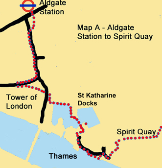
1. Leave Aldgate Station and cross Aldgate High Street. Walk ahead down a pathway to the left of a bus depot to reach a road called Minories. Turn left here and cross to the right-hand footway. Go underneath a bridge and continue to the end of the road to reach Tower Hill. Still staying on the same footway, you swing right. After 100m you go down to a pedestrian underpass on your right which takes you under the road. You come out onto a walkway with the Tower of London ahead. Turn left and follow the walkway for 250m to go through a pedestrian tunnel. At the end of the tunnel, turn right and walk down an alleyway with an office block on your left. Turn left and enter St Katharine Docks.
2. Go ahead along a boardwalk, with the dock to the right and restaurants to the left. Turn right at the corner and continue with the water on your right. Go through a walkway under some buildings and emerge facing another dock. Turn left, continue to the end of the walkway and turn right over a metal bridge. The Dickens Inn is on your left. Turn half-right and walk across a pedestrian area to turn left to pass between buildings. The one on the left is called Marble Quay. Exit St Katharine Docks and go ahead on St Katharine’s Way. After 100m look out for a pathway on the right with a Thames Path sign. Follow this down to the Thames to a terrace which has a fine view back to Tower Bridge. At the end of the terrace, turn left in order to join St Katharine’s Way again, at the point where it joins Wapping High Street.
3. Turn right and walk for 40m across a bridge. Do not continue ahead along the riverside, but turn left towards a sign for "Redmead Lane Leading to Hermitage Walk". Pass through a gateway and enter Hermitage Basin, with the water on your left. At the end of the basin turn left and then right to descend some steps. Go ahead briefly and turn right, following signs for Shadwell Basin, to reach Spirit Quay. Follow the quayside for 1 km as it turns left and then right. You pass Tobacco Dock, where there are two ships in dry dock. Continue under a bridge and ascend slightly to reach an area of grass and trees with the grand title of Wapping Woods. Continue across, and slightly to the left, on a broad path, to reach a waterside walkway on the other side.
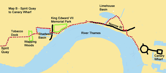
4. After another 150m reach Shadwell Basin. Turn left and walk around three sides of the dock to reach Glamis Road. On your right is a bridge which in former times could be raised to allow ships to enter the docks. Beyond that, you can see The Prospect of Whitby, reputed to be the oldest riverside pub in London and well worth a short detour. Cross Glamis Road and enter a pathway with a Thames Path signpost. Walk down to the river. Turn left and walk through the King Edward VII Memorial Park along the river bank.
At the time of writing, there were diversions here around the construction site of London’s new super sewer. Follow the riverside for 400m. Turn left and right around a block of flats to join Narrow Street and walk ahead for another 400m to cross a bridge at the entrance to Limehouse Basin. Turn left along the right-hand side of the marina and climb some steps to cross a metal bridge over Limehouse Cut. At the end of the bridge turn right and walk for 50m to turn right again over another bridge. Enter a small park called Ropemakers Fields. Walk through the park to emerge again on Narrow Street.
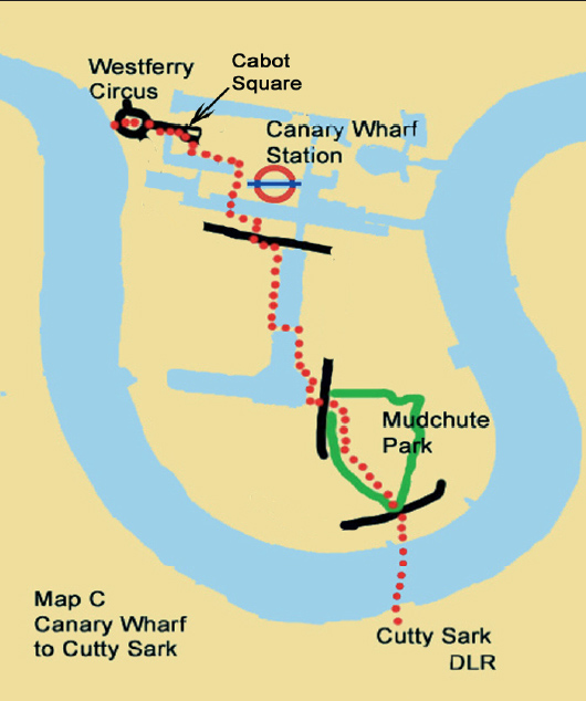
5. Turn left for 50m and then turn right to pass between buildings and join a walkway beside the river. Cross a curving bridge and turn left along the Thames to reach Canary Wharf Pier. Turn left and climb the steps leading to street level. Go ahead across Westferry Circus and join West India Avenue, a dual carriageway which leads directly towards the high-rise buildings of Canary Wharf. Walk up to Cabot Square with its fountains. From the centre of Cabot Square, turn right, cross a road and go down Cubitt Steps. Turn left along MacKenzie Walk, past restaurants and bars. Go under the Dockland Light Railway and continue to Reuters Plaza. Turn right with the Jubilee Line Station on your left. You can return to Central London from here.
6. To continue the walk, go past the station entrance and across a road, towards 35 Bank Street. The foyer of this building is a pedestrian route. Enter and walk ahead to exit on the far side of the lobby. Climb some steps and cross a metal bridge over South Dock. Turn left at the end and walk along the quayside for 200m. Turn right between some low-walled grassy beds to a road (Marsh Wall). Cross at the pedestrian lights and turn left beneath the track of the DLR.
7. Before reaching the entrance to South Quay DLR Station, turn right and walk down the side of Millwall Inner Dock. After 500m, at Pepper Street, turn left over a small bridge. Turn right and walk with the water now on your right. After 200m the walkway swings to the left and you can see Millwall Outer Dock, a large area of water on your right. Turn left on a path which goes through the centre of a semi-circular area of grass. Descend some steps, go under the DLR and cross East Ferry Road to enter Mudchute Park. Climb up some steps and turn right along an elevated path.
8. Walk for 200m to a corner where the path turns left. Leave the path, go down a ramp and go through a gate. Turn left into a large playing field. Walk to the far right-hand corner. Go past the entrance to Island Gardens DLR, cross the road and walk ahead to the River Thames and the entrance to the Greenwich Foot Tunnel, taking a moment to admire the view across the river to Maritime Greenwich, with the Royal Naval College in the foreground and the Royal Observatory on the hill behind it. Walk through the foot tunnel and come out beside the Cutty Sark.
Information on Things You Will See
St Katharine Docks took their name from a 12thC hospital which stood on the site. The area was redeveloped by an Act of Parliament in 1825, and all the local houses were demolished, together with the medieval hospital. The "modernisation" was designed by engineer Thomas Telford and was his only major project in London. To create as much quayside as possible, the docks were designed in the form of two linked basins both accessed via an entrance lock from the Thames. The new docks were officially opened in1828 and although well used, they were not a great commercial success as they were unable to accommodate large ships. They were badly damaged by bombing diuring the second world war and were finally closed in 1968. In the 1970s most of the original warehouses were demolished and replaced by modern commercial buildings. The area is now a popular leisure destination and features offices, private housing, a large hotel, shops and restaurants, a pub (the Dickens Inn) and a yachting marina.
Shadwell Basin is the most significant body of water surviving from the historical London Docks. Unlike the rest of the London Docks, which have been landfilled, Shadwell Basin, has been retained and is used for recreational purposes including sailing, canoeing and fishing. It is surrounded on three sides by a modern waterside housing development.
The Prospect of Whitby is a historic public house and claims to be the site of the oldest riverside tavern dating from 1520. It was formerly known as the Pelican and Devil’s Tavern. In the 17thC it was the regular hostelry of “hanging” Judge Jeffreys. A replica gallows and noose hangs near one of the windows commemorating his custom. According to legend, criminals would be tied up to posts in the water at low tide and left there to drown when the tide came in. Following a fire in the early 19th century, the tavern was rebuilt and renamed The Prospect of Whitby, after a Tyne collier that used to berth next to the pub.
Limehouse Basin, in the borough of Tower Hamlets, creates a navigable link between the River Thames and two major inland waterways: (1) the Regents Canal which leads to the Grand Union Canal and (2) the Lee Navigation via the Limehouse Cut. Built by the Regent's Canal Company, Limehouse Basin was formerly known as Regent's Canal Dock and was used by seagoing vessels and lighters to offload cargoes to canal barges, for onward transport along the whole of the canal network. In the mid19th century the dock and the canal were a major commercial success and supplied coal to gasworks and, latterly, electricity generating stations. The basin is now used largely for recreation and leisure and the once derelict land surrounding it has been developed into luxury flats.
Cutty Sark is a British Clipper ship built on the River Clyde in 1869. She was one of the last tea clippers and one of the fastest, coming at the end of a long period of design development, which ceased when sailing ships gave way to steam propulsion. The opening of the Suez Canal meant that steamships enjoyed a much shorter route to China. So, Cutty Sark spent only a few years on the tea routes before turning to the trade in wool from Australia where she held the record sailing time to Britain for ten years. She continued as a cargo ship but was purchased in 1922 by retired sea captain Wilfred Dowman, who used her as a training ship operating from Falmouth. After his death, Cutty Sark was transferred to the Thames Nautical Training College and was later moved to a permanent dry dock for display and has become an iconic feature of Greenwich riverfront.

- Details
- Hits: 10562
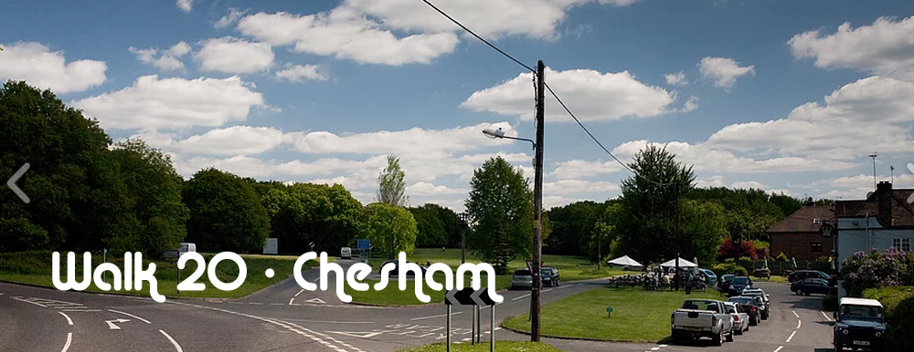
Walk 20 - From Chesham, at the Western End of the Metropolitan Line to Chalfont Latimer via Ley Hill
|
Distance8 |
11 km (7 miles) |
|
Underfoot |
Fotpaths and country tracks, may be muddy in winter or after rain |
|
Outward Journey |
Metropolitan Line to Chesham (About 55 minutes from Central London |
|
Return |
By Metropolitan Line from Chalfont & Latimer Station |
|
Points of Interest |
Chesham, Chess Valley |
|
Refreshments |
Pubs at Ley Hill |
|
Public Toilets |
At Chesham Station |
|
Shortening the Walk |
At Point A - return to Cesham on the Chess Valley Walk |
What To Expect From This Walk
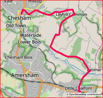
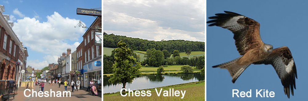
This is a lovely walk in the Chiltern Hills, well beyond the boundary of London. Chesham is a traditional Chilterns market town and it is worth taking some time to visit the attractive High Street. The walk offers fine views over the town and its surrounding hills. There are a few ups and downs but nothing too strenuous. At about half-way, you arrive at Ley Hill with two adjacent pubs. You then walk downhill into the Chess Valley, before turning east through lovely countryside to Little Chalfont. Do look out for the red kite, a bird of prey which was driven to extinction in England by the end of the 19th century. Following their successful reintroduction into the Chilterns between 1989 and 1994, as part of a conservation project, there are now estimated to be over 1,000 breeding pairs in the area.
Route Directions
1. Leave Chesham Station and walk ahead on a road called The Backs. At the first junction (Whites Hill) turn right up some steps. Go past an entrance and continue steeply uphill for 50m. Turn right and go through a gate. Enter a field and climb straight ahead to another gate which is clearly visible ahead. Behind you, there are good views across Chesham. In the next field, continue in the same direction to the top of the hill and go through another gate. Turn left and walk to the corner of the field. Go through a gate, turn right and walk along an enclosed path. At the end, turn half-left and strike out diagonally across a field on a clear path. Cross a farm access track and go ahead to follow the left-hand edge of a field.
2. Enter the next field and go straight ahead. (If the field has been recently ploughed, you can turn left and follow its margin.) Reach the other side and turn right but after only 30m turn left again through a gap in the hedgerow and walk downhill to a bridleway. Go straight across and climb the clear path on the other side. When you reach the corner of a field, with more good views all around, turn left with the hedge on your right and walk to the end of the field. Go through a gate and continue in the same direction to reach Tylers Hill Road. Turn right and pass a house called Five Bells and a brick-built church. At the gates of Cowcroft Grange, turn left on a track through woods. Emerge on a lane and continue for about 400m in the same direction until you reach a junction. Turn right into Blackwell Hall Lane, where there were two pubs, The Crown and The Swan. I understand the Swan has now closed. Continue past the pubs.
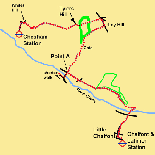
3. After 250m turn right on a footpath, which starts as a concrete farm track. Where the track swings right, continue straight ahead to the right of a hedge. When you reach a wood there are several routes. Ignore a path to the right which leads into the wood. Your direction is straight on, on a path which goes through a small section of the wood and then runs down the left-hand perimeter of the wood. When you go past a field entrance with a metal gate, look for a wooden gate just beyond it. Go through the wooden gate and descend diagonally across a large field with many oak trees. Go through a gate at the bottom right corner. Turn right on a track (Green Lane) for 150m and then take the first footpath on your left. Follow this footpath downhill for 600m until you see a road ahead.
This is Point A, where the shorter walk back to Chesham goes straight on from Point A up to the road. Where the path meets the road, continue ahead on the road to cross the river. After 200m, turn right into Hollow Way Lane and then follow the signs for the Chess Valley Walk
4. For the full walk, turn left just before you reach the road, on the signed footpath to Blackwell. Go along the bottom edge of a field to a gate. Continue ahead across the next field and arrive at Blackwell Hall. Follow the path to the right and reach a lane. Turn left on the lane for a short distance before continuing ahead on a footpath signed Chess Valley Walk.
5. Walk through several fields, staying close to the edge of the field on your right. At the end of the final field, go through a gate and follow a path along the edge of a wood. Cross over the first stile on your right to enter a large field. Turn left inside the field and climb a hill with the wood on your left. You may notice a parallel footpath on the other side of the fence, but do not worry, you are meant to be in the field. Take time to admire the views behind you. Turn right at the end of the field and continue to walk along the field edge, with the wood still on your left. Turn left at a corner of the wood on a track which leads along the side of the valley, with good views of the River Chess.
6. After passing Latimer House Hotel on your left, you reach a surfaced crossing track between fences. Turn right on this track and descend towards the river. At the bottom, cross a bridge below a weir, go through a gate and walk across a field to reach a road. Go across the road and enter another field. After 20m take the right-hand of two paths and walk to the top corner of the field. Enter a wood and climb diagonally uphill on a clear path. Go straight over a broad crossing track and continue uphill, maintaining the same direction.
7. With the top of the hill in view, take the right-hand path at a fork. When you reach some houses, take the unsurfaced road (Chenies Avenue) which goes left into the village of Little Chalfont. The road soon becomes a fully paved residential street. Follow it downhill, cross a larger road, and continue to descend. When you reach a T-junction, with the station car park visible ahead, turn left into Bedford Avenue. After 250m turn right and go up the steps in order to reach Chalfont & Latimer Station.
Information On Things You Will See
The Red Kite is medium sized bird of prey in the family Accipitridae which includes eagles, buzzards and harriers. The Chilterns is one of the best places in the UK to see red kites, thanks to a successful re-introduction project between 1989 and 1994. They were driven to extinction in England by human persecution by the end of the nineteenth century. A small population survived in Wales, but there was little chance of these birds repopulating their original areas. Between 1989 and 1994, kites from Spain were imported and released into the Chilterns by the RSPB and English Nature. Now, there are estimated to be over 1,000 breeding pairs in the area. Since 1999, chicks have been taken from the Chilterns to reintroduction other sites in the UK. The red kite reintroduction has proved to be one of the most successful conservation stories of the 20thC.(See http://www.chilternsaonb.org/red-kites for more information.
Chesham is a market town in the Chiltern Hills in Buckinghamshires. It is situated in the Chess Valley and is surrounded by farmland. The earliest records indicate that it has existed since at least the 10thC. Henry III granted the town a royal charter to hold a weekly market in 1257. The town is best known for its “four Bs” usually quoted as "boots, beer, brushes and baptists." A clock Tower constructed in 1992 stands in Market Square on the site of Chesham's 18th-century town hall which was demolished in 1965. The turret is a reconstruction of the one built onto the original town hall in the 19th century and features the original glass-dialled clock face and clock mechanism from the mid 19th century. Transport connections came to the town. It was not until July 1889 that the Metropolitan Railway connected with Chesham and electrification did not take place until the 1960s.
- Details
- Hits: 8504
Walk 19 - From Watford, at the Western End of the Metropolitan Line to Chorleywood via Whippendell Woods and the Chess Valley
|
Distance |
11 km (7 miles) |
|
Underfoot |
Woodland paths, tracks and field edges |
|
Outward Journey |
By Metropolitan Line to Watford - about 40 minutes from Central London |
|
Return |
By Metropolitan Line from Chorleywood |
|
Points of Interest |
Cassiobury Park, Sarratt, Chess Valley |
|
Refreshments |
Cafe in Cassiobury Park and Cock Inn at Sarratt |
|
Public Toilets |
At Watford Station |
|
Shortening the Walk |
Infrequent weekday bus (352) from Sarratt to Hemel Hempstead or Watford |
What to Expect From This Walk
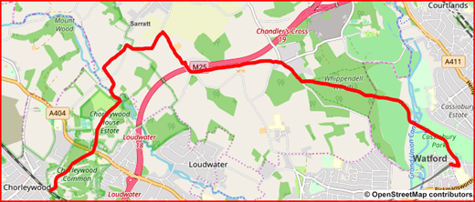
This walk is a mixture of woods, parks and open fields. It passes through Cassiobury Park, and then crosses the Grand Union Canal to Whippendell Woods, full of bluebells in springtime. Later, open fields lead to the hamlet of Sarratt, with its almshouses and 15th-century church. Next, you descend into the beautiful Chess Valley and climb out the other side to finish the walk at the town of Chorleywood
Route Directions
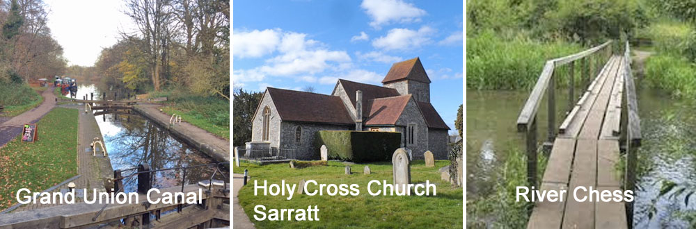
1. Turn right as you come out of the station and walk for 150m. Turn left at the traffic lights by the entrance to Cassiobury Park. Go into the park and go ahead to a junction of paths where you turn left onto a path which veers to the right between trees. Carry on for 400m to another junction, where you turn left downhill along an avenue of trees. After 300m you come to a café on the left, near a children’s play area. Continue down the path and cross two bridges, the first over the River Gade, the second over the Grand Union Canal.
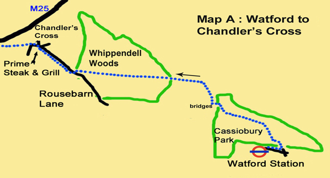
2. After the second bridge, turn right and follow a broad track, which at first runs parallel to the canal but soon swings away to the left and rises to cross the West Herts Golf Course. Continue until you reach a junction with a sign for Rond Point. Leave the track and take the path straight ahead, signposted to Chandler’s Cross. Descend through Whippendell woods and continue to follow this well-walked path for the next kilometre, ignoring all turnings to the left and to the right until you reach a gate next to an information board at Rousebarn Lane.
3. Turn right and walk for 600m to reach a junction of roads at Chandler’s Cross. Turn left and ignore a road coming in from the right. Go to the left of a restaurant and where the road takes a sharp bend to the left, continue straight ahead on a track between hedges, signposted Micklefield Green. Continue on this track for 1.8 km. Soon you are walking alongside the M25 motorway. When you reach a road, turn right on a bridge over the motorway. Turn left on a driveway which crosses the path and leads out to a road. Cross the road to a stile with two signposts. Climb over the stile and turn right along the field edge, following the sign for Sarratt.
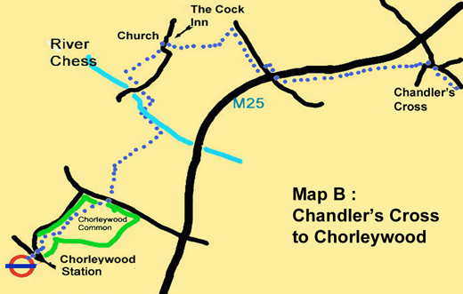
4. Continue along the field edge for 250m. Go past the access gateway to New Model Farm and return to the field edge for another 250m. At the end of the second field, make sure you do not go through a metal gate ahead of you. Instead, turn left and walk to the next corner, with the hedge on your right. Go through a gate in the hedge and walk diagonally right across a field. At the far side, go right and then cross a stile with a sign for the Sarratt Parish Footpath. Turn right after the stile to reach the Cock Inn car park. Turn left onto a lane. Pass the inn on your left and Holy Cross Church on your right.
5. Turn right and walk past the former almshouses at Church End, founded in 1700, although the current red-brick houses are late Georgian (1821). Enter an enclosed path, cross a driveway and walk downhill with good views ahead, past a hedge on your right, which is followed later by a metal fence. You are descending into the valley of the River Chess. At the bottom of the hill, turn left on a track to join the Chess Valley Walk.
6. Cross a road and continue ahead on a path which soon turns right and crosses the river by way of a wooden walkway and bridge. After crossing the bridge, turn left and walk for 300m to a junction of paths. At the point where your path swings left, turn right on a smaller path and walk uphill, just inside a wood. At the top, continue straight ahead on a broad track. After 350m the track reaches a junction. Turn right and then left onto a paved driveway which first goes downhill but then rises again. There is a large grassy area on your right and (later) a small cemetery to your left. 7. When you reach Rickmansworth Road (the A404), cross over with care. Walk diagonally right along a broad grassy avenue between trees. Ahead you can see the outskirts of Chorleywood. You can also see a road away to your right. To reach it, go across the common and through a car park out onto the road. Immediately after the car park entrance, there is a green sign pointing right towards to the station. Go downhill in the direction indicated, through the gates of a small housing development called Betjeman Gardens. Follow the driveway as it takes you right and then left between houses and then watch out for the steps which lead down to Chorleywood Station.
Information On The Things You Will See
Watford is a town and borough in Hertfordshire, 15 miles (24Km) northwest of Central London. It should not be confused with Watford, Northamptonshire which is 55 miles to the the north. The town belonged to St Albans Abbey until the 16thC. Connections to the Grand Union Canal and the London to Birminham Railway allowed the town to grow rapidly in the 19thC with paper-making, printing and brewing as its main industries.
Cassiobury Park is the largest public open space in Watford comprising of over 190 acres of green space stretching from the town centre to the Grand Union Canal. It contains a variety of sports facilities and parts of the parkare designated as a nature reserve. The Earls of Essex lived in a mansion called Cassiobury House (now demolished) for 250 years until the early 20thC.
Chorleywood dates from the Paleothithic era when the plentiful availability of flint led to swift development of tools by man. The Romans built a village here complete with a mill and brewery. A large influx of Saxon settlers called it 'Cerola Leah', meaning a meadow in a clearing. Edward the Confessor gave Chorleywood to the Monastery of St Albans and later it passed to the Bishopric of London, being renamed 'Charleywoode'. The Turnpike Act (1663) gave Chorleywood a chance to exploit its strategic position, allowing locals the opportunity to charge civilians to use the road from Hatfield to Reading. Chorleywood is also famous for its Quakers who were given sanctuary by the locals.
The Chess Valley Walk is a 10 mile walk from Chesham to Rickmansworth. The Chess Valley has some of the most attractive countryside in the Chilterns Area of Outstanding Natural Beauty. Along the way there are historic buildings and estates, water meadows, ancient field systems and nature reserves. The Chess is a chalk stream and is fed by groundwater, which is stored in the aquifer – layers of chalk rock which work like a sponge, soaking up water until it emerges at ground level. Regular winter rainfall is needed to recharge the aquifer and keep the chalk streams of the Chilterns flowing throughout the year. Typical chalk streams, like the Chess are shallow, narrow streams, with gravel beds and clear, warm water.