- Details
- Hits: 7628
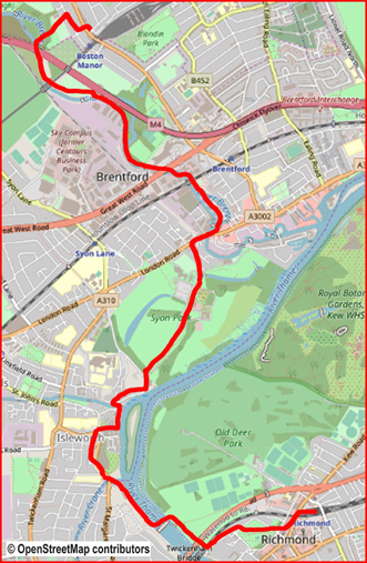
Walk No 14 - From Ricmond, at the western end of the District Line, to Boston Manor
|
Distance |
8 km (5 miles) |
|
Underfoot |
Paved paths except for 300m near the end |
|
Outward Journey |
District Line to Richmond or mainline train from Waterloo - about 30 minutes from Central London |
|
Return |
By Piccadilly Line from Boston Manor |
|
Points of Interest |
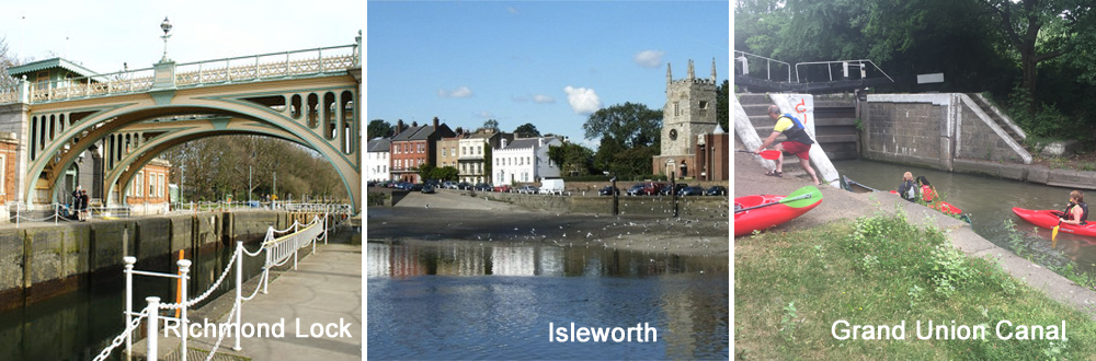
Richmond Lock, Isleworth Riverside, Syon House, Grand Union Canal |
|
Refreshments |
Pubs in Richmond, Isleworth and Brentford. Cafe in Syon Park Garden Centre |
|
Public Toilets |
At Richmond Station and Syon Park Garden Centre |
|
Shortening the Walk |
Catch a bus from Brentford to Kew or Richmond Stations |
What To Expect From This Walk
This is an easy walk which includes an attractive section of the River Thames. It has plenty of refreshment stops. As in walk 13 you start off by crossing the attractive Richmond Green and the Swan PH. Upon reaching the Thames you turn right and cross the river at the 19thC Richmond Lock. There is 400m of road walking before you reach the attractive Isleworth riverfront with two more pubs. After this there is a pleasant walk through Syon Park passing a garden centre cafe before reaching Brentford and the Grand Union Canal. Walk for 3Km up the canal and then swing right to reach Boston Manor Tube Station.
1. Cross the road at the pedestrian lights in front of Richmond Station and go ahead through an alleyway. Turn left and walk along a road called Little Green. Very soon, you will be able to see Richmond Green on your right. Take the diagonal path which cuts across the centre of the Green. Cross over a small road and continue in the same direction to the far corner of the Green. Enter Old Palace Lane and follow it down to the River Thames, passing the White Swan pub.
2. Turn right on the riverside path. Pass under two bridges and walk for 350m to Richmond Lock. Use the footbridge to cross the Thames. Continue along the opposite bank in the same direction as before. When you reach the end of the riverside path, swing left on a small road to reach a main road (St Margarets Road).
3. Turn right and walk for 400m, passing the sign for Isleworth. Where the main road turns left, turn right on Lion Wharf Road and walk down to the riverside. Turn left and pass between Town Wharf pub and the river. Where a small river (the River Crane) enters the Thames, you are obliged to turn inland and cross a bridge. Continue past another pub, The London Apprentice. You now have a good view of the river, with Isleworth Church on your left. Swing left with the road. Within 100m there is a gate on your right, signed Syon Park. Enter the park and walk ahead, close to its right-hand perimeter. After 300m there is a fine view of Syon House to your right.
4. You then arrive at Syon Park Garden Centre, which has a tea room and toilets. Continue ahead past a car park. The road narrows to become a broad footpath which swings left through gates to come out onto the A315 (London Road). Turn right here and walk 200m towards a bridge over the Grand Union Canal at Brentford.
5. Just before the bridge, cross the road and go down to the canal. There are signs indicating your route to Osterley and Hanwell. Follow the towpath past modern waterside developments. You will see the prominent offices of GlaxoSmithKline on the opposite bank ahead of you. You will also hear the traffic on the M4. Continue on the towpath to cross a footbridge bearing the logo of the Grand Central Canal Company 1820.
6. Continue on the towpath on the other side of the canal and pass under two more bridges. Immediately after the second bridge (which carries the M4), leave the canal and turn right, signposted to Boston Manor Station. Take the left-hand of two paths, beside a stretch of the River Brent. Climb the path and go ahead at the top of the hill to reach Southdown Avenue. Turn right and continue to the junction with Wellmeadow Road. Turn left here and then right on Boston Road to reach Boston Manor Station.
Information on Things You Will See
Richmond Lock is the furthest downstream of all the locks on the River Thames and is the only one operated by the Port of London Authority. It permits passage of vessels up to 250 feet long. The Richmond Lock and Weir Complex was opened in 1894 and is designed to maintain a navigable depth of water upstream of Richmond. It was needed because when the old London Bridge was demolished in 1832, the removal of pallisades constructed to protect the bridge, resulted in the tides on the upper Thames rising and falling far more than they had done previously. As a consequence, the river at Twickenham and Richmond was often little more than a stream running through mudbanks. Technically, Richmond Lock is a half-tide lock and barrage, which comprises three vertical steel sluice gates suspended from the footbridge structure. These gates weigh 32 tons each and are 66 feet in width and 12 feet in depth. For about two hours each side of high tide the sluice gates are raised and river traffic can pass through unimpeded. For the rest of the tidal cycle the sluice gates are closed, and ships and boats must use the lock.
Richmond Lock Footbridge The footbridge crosses the conventional lock and is an integral part of the barrage system. It connects Richmond on the east bank with the neighbouring district of St Margarets the west bank but is closed at night to pedestrians at 19.30 in the winter and 21.30 when British Summer Time in in effect.
Syon House and Park, lie within within the parish of Islewoth in the county of Middlesex. It is the London residence of the Duke of Northumberland. Syon Park borders the Thames opposite Kew Gardensand contains a tidal meadow flooded twice each day by the river. The London Butterfly House was based in the grounds of Syon Park from 1981 until its closure on 28 October 2007 due to plans to build a hotel complex on the land. In 2011, the Syon Park Waldorf Astoria hotel opened on the site. The hotel was renamed to the Hilton London Syon Park in 2013


- Details
- Hits: 8447
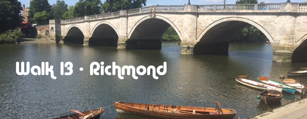
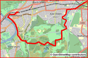
Walk No 13 – From Richmond, at the western end of the District Line to Barnes via the Thames Path and Richmond Park
|
Distance |
10 km (6 miles) |
|
Underfoot |
Good paths throughout |
|
Outward Journey |
District Line to Richmond or mainline train from Waterloo - about 30 minutes from Central London |
|
Return |
By train from Barnes |
|
Points of Interest |
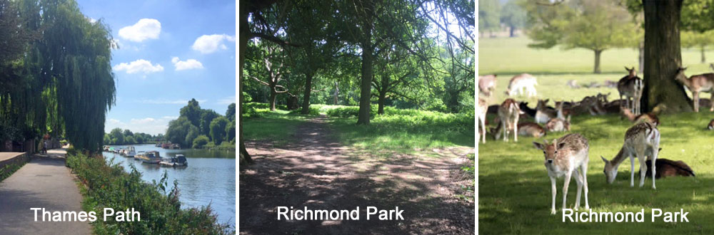
Thames Path, Richmond Park |
|
Refreshments |
Pubs and cafes at Richmond, cafe and refreshment kiosk at Pembroke Lodge |
|
Public Toilets |
At Richmond Station and Pembroke Lodge |
|
Shortening the Walk |
Catch a bus back to Richmond about 1.5 km from the end |
.
What to Expect From This Walk
This is a lovely walk which makes best use of the beautiful countryside near Richmond. It starts across Richmond Green and then uses the Thames Path to connect with Richmond Park. The traverse of the park makes up about half the walk. The final part of the walk makes use of the Beverley Brook Trail to reach East Sheen and Barnes.
1. Cross the road at the pedestrian lights in front of Richmond Station and go ahead through an alleyway. Turn left and walk along a road called Little Green. Very soon, you see Richmond Green on your right. Take the diagonal path which cuts across the centre of the Green. Cross over a small road and continue in the same direction to the far corner of the Green. Enter Old Palace Lane and follow it down to the River Thames, passing the White Swan pub.
2. Turn left and pass under Richmond Bridge. Continue along the riverside and enter Buccleuch Gardens. Do not take the well-worn path which goes off to the right. Instead, continue on the paved pathway. Ignore some steps on the left and go ahead to a small gate, signposted Petersham. Walk across a meadow and go through a gate into an enclosed path. Walk to the end of this and continue for another 100m on a small road. Look out for a Capital Ring sign on a brick wall indicating a pathway to the left.
3. Turn left and follow the path to a road. Cross the road and enter Richmond Park. Go left, diagonally uphill, following the signs for the Capital Ring and Pembroke Lodge. As you climb the hill, a fine view opens up behind you. Near the top, go up some steps and through a large metal gate. Turn right. There is a rose garden to your left and another chance to admire the view over West London. Go ahead along the path to Pembroke Lodge, a Georgian mansion which has a popular café.
4. Turn left, go around the lodge and exit through its main gateway into a car park with a refreshment kiosk. Go through the car park and cross a road. Turn right along the verge and walk as far as the first track going left. Turn left here to follow the track along the perimeter of a wood. Where the paved track swings left into a works depot, go ahead, still along the edge of the wood. Continue until the track reaches a five-way junction, at which point you can see two lakes in the distance. Take the right-hand path of the three paths ahead of you. Go over a crossing path and then turn right on a larger track which leads down to the lakes. Walk down towards the lakes. Just before reaching them, turn left to walk along the edge of one of the lakes.
5. At the corner of the lake, turn right and continue beside the water. When you reach the end of the lake, go straight ahead uphill to reach an asphalt road. Turn left and pass in front of the aptly named White Lodge. Walk for another 200m to reach a junction with a road which goes back right at an acute angle, marked White Lodge Only. At this point leave the tarmac and turn right on a path going off towards the trees. Follow the path as it swings right, then left, then straight on through the woods, always parallel to a large open section of the park which you can see to your left. In a clearing with several fallen tree trunks, turn left onto a crossing path which after 500m leads you down to the vehicle road crossing the park. Turn right and follow the road across the Beverley Brook. Exit Richmond Park by the Roehampton Gate and immediately look out for a Beverley Brook Walk sign pointing left.
6. Turn left and follow an enclosed path, with the wall of the park on your left and the brook on your right. Go through a gate, swing right and continue walking alongside the brook. The view opens out on the left, across a playing field. At the end of the field, turn left on a paved path and continue to follow Beverley Brook on your right. After 250m the path leaves the brook and leads you between allotments to reach a road (Hertford Avenue). Turn right and follow this road until it reaches Upper Richmond Road (the A205).
7. If you wish to shorten the walk by taking a bus back to Richmond Station, turn left here to find the nearest bus stop and catch a no. 33 or no. 493. Otherwise, turn right and cross the road. Walk for 800m to the traffic lights at the junction with Vine Street. Take the path which goes diagonally left across East Sheen Common, signed as a footpath to Barnes Station, with mainline trains to London.
Richmond Green is said to be one of the most beautiful urban greens in England. It is square in shape and roughly twelve acres in size. On the north-east side there is a smaller open space called Little Green. Both are overlooked by a mixture of period townhouses, historic buildings and municipal and commercial establishments including Richmond Theatre. It has a long history of hosting sporting events. In the 16th century tournaments and archery contests are known to have taken place. More recently cricket has been the sport of choice and matches have occurred from the 18th century up to the present day.
The Thames Path is a National Trail which runs between the source of the river near Cirencester in Gloucestershire to the Thames Barrier at Charlton a distance of 296Km (184 miles).
Richmond Park, was created by Charles I in the 17th century as a deer park. At 2,360 acres it is the largest of London's Royal Parks and is of national and international importance for wildlife conservation. It is a place of many walkers, cyclists and horse riders and is home to roughly 630 red and fallow deer which roam freely through the park.
White Lodge is a Grade I listed Georgian House. Formerly a Royal residence, it is now the home of the Royal Ballet Lower School instructing students aged 11 to 16 years. In the mid 18thC the lodge was frequently occupied by Queen Caroline, the consort of George II. It was built as a hunting lodge for George II and was completed in 1730.
Pembroke Lodge is another listed Georgian mansion. It is located on high ground with views across London and the Thames Valley. It has 11 acres of landscaped grounds. The building was once the home of the British Prime Minister John Russell and was the childhood home of his grandson, the philosopher, Bertrand Russell. It is part of the Crown Estate and is now run as a catering facility, conference centre and wedding venue. Situated on Poet’s Corner in Pembroke Lodge Gardens lies the Ian Dury bench, in memory of the rock star best known for his songs Hit Me with Your Rhythm Stick and What a Waste.
Beverley Brook rises in Worcester Park and flows north east to join the Thames at Barn Elmes between Barnes and Putney. It is 14.3Km (9miles) long. In Richmond Park it creates a water feature much used by deer and smaller animals.
- Details
- Hits: 9182
Walk No 12 - From Ealing Broadway, at the Western End of the Central and District Lines, to Boston Manor

|
Distance |
13 km ( 8 miles) |
|
Underfoot |
Roads or good footpaths |
|
Outward Journey |
By Central or District Line to Ealing Broadway - about 25-30 minutes from Central London |
|
Return |
By Piccadilly Line from Boston Manor |
|
Points of Interest |
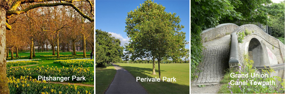
Pitshanger Park, Perivale Park, River Brent, Grand Union Canal |
|
Refreshments |
Cafés in Pitshanger Park and Perivale Park, The Viaduct pub at Hanwell Bridge |
|
Public Toilets |
At Ealing Broadway Station. Pitshanger Park |
|
Shortening the Walk |
You can catch and E8 bus from Hanwell Bride back to Ealing Broadway |
What To Expect From This Walk
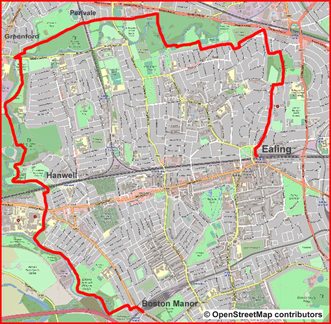
This walk makes maximum use of green spaces and riverside paths in this pleasant part of London. It starts at the busy terminus point of Ealing Broadway but soon enters leafy suburban streets and pedestrianised byways which lead northwards to Pitshanger Park and the green tract of land which marks the progress of the River Brent. At Perivale Park the route meets the Capital Ring footpath and follows it to the Grand Union Canal. After about 1 mile on the towpath the route turns away to reach Boston Manor Tube Station.
1. Turn right out of the station and walk to a road junction. Cross at the pedestrian crossing and enter Mountfield Road, the middle of three roads opposite. Walk to the end of Mountfield Road, cross Woodville Road and enter Hillcroft Crescent. Where the road turns left, go straight ahead and enter West Walk, a pedestrian and cycle shared path, which starts to climb gently. At the end of West Walk, go ahead along the footway for another 150m to reach a hedge with a sports ground visible beyond. Turn right and after 100m turn left into Fox Lane, another shared path. Walk to the end and turn left into Sandall Road. In 100m turn right into Lynwood Road and walk towards Western Avenue (A40).
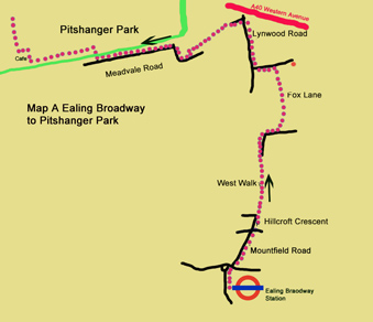
2. Go over the junction with Brunswick Road. Just before reaching the A40, turnleft into an unmarked drive between houses and garages. Continue on a path with allotments on your right. When the path reaches a fence, turn left and arrive at a suburban road where there is a sign for Brent River Walk. Turn right here and right again into Neville Road. Turn left into Meadvale Road, as indicated by another Brent River Walk sign. Walk along the right-hand footway for 550m to reach the entrance to Pitshanger Park on your right. Enter the park and turn left on a broad path to pass some tennis courts. At the far end of the tennis courts, turn right and reach the Tennis Courts café.
3. Continue past the café and turn left along the edge of the park. After 70m turn right onto a crossing path towards Perivale. Follow this path between fences and over a bridge. This is your first sight of the River Brent. Continue past a weatherboarded church. Go through a lych-gate and turn left into Perivale Lane. Walk for 400m to the junction with Argyle Road and cross with care at the traffic lights, which have no pedestrian phase. Go ahead into the road opposite, Stockdove Way, and continue for 300m to pass under a railway bridge. Ahead to your left, you can see Perivale Park Golf Club shop and café. To your right is a sports stadium. Pass between the café and the stadium to reach a vehicle barrier.
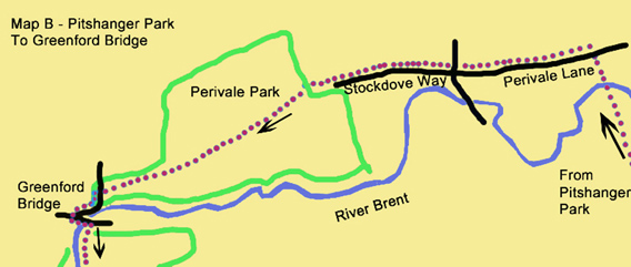
4. Do not go ahead on the track around the perimeter of the sports ground. Instead, turn diagonally left along the line of a hedge on a gravel track, past a wooden post. Follow the track and continue in the same direction, down the line of bushes and rough grass which marks the boundary between the park on your right and the golf course on your left. After 250m you reach a path which comes in from the right and turns to continue in your direction of travel. You are now on the Capital Ring and you will follow it for almost all the rest of the walk. Continue ahead and cross a bridge. Emerge on Costons Lane and turn left to reach a larger road (Ruislip Road) on the outskirts of Greenford. Turn left over a bridge, cross the road and turn right onto a path with Capital Ring waymarks. In this section, the river, which is on your right, is often hidden from sight by undergrowth.
5. After 700m, where the path swings left, look out for a marker post on your right. Go down some steps to the river bank and turn left along it. After 200m, rejoin the main path and within 100m come to a wooden bridge. Turn right and go across the bridge to the other bank of the river. Go ahead for 50m and then turn left on a path across Brent Valley Golf Course. Walk for 800m to a metal footbridge, which takes you back to the left bank of the river. Turn right and follow the meanders of the river on a grassy path beside the riverside undergrowth.
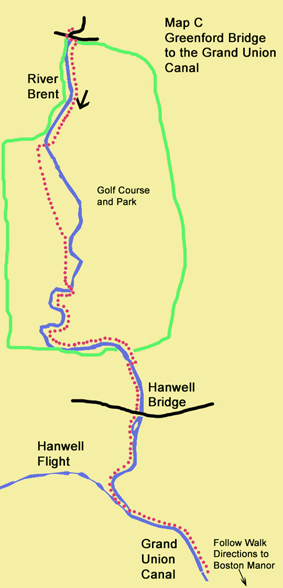
6. Go over a bank and follow a wider pathway to the right to reach a number of fingerpost signs. Your onward route is indicated by the sign which points to Osterley Locks and Brentford. Join a track, which swings right to pass under a very large railway viaduct. footbridge takes you back to the right- hand bank and soon you reach Hanwell Bridge. You can find The Viaduct pub by crossing the bridge. If you wish to shorten the walk at this point, catch an E8 bus back to Ealing Broadway.
7. To continue the walk, go under the bridge and follow the footpath beside the river for another 700m to the Grand Union Canal and the Hanwell Flight of Locks. To see the full extent of the locks, turn right. Otherwise, turn left and walk down the canal towpath for 1.3 km. Continue over a concrete walkway at Osterley Weir, past a lock. Ahead, you will see the M4 motorway bridge over the canal. Just before the bridge, turn left at a signpost for Boston Manor Station. Take the left-hand of two paths, initially beside another stretch of the River Brent. Go ahead at the top of the hill. When you reach a residential road (Southdown Avenue), turn right and walk to the junction with Wellmeadow Road. Turn left and then right on Boston Road to reach Boston Manor Station.
Information On The Things You Will See
The River Brent is a tributary of the River Thames. It comes into existence at the junction of Dollis Brook and Mutton Brook near Hendon in the Borough of Barnet and runs for 29Km (18miles) to join the Thames at Brentford. (See Walk 7 for more information on the Dollis Brook Greenwalk). The river corridor has been subject to flood alleviation in parts, meaning that the banks are generally not natural to wildlife. . However, there remain many old trees along the river’s course plus some high-quality grasslands and woodlands. Much of the open space in the park is mown grassland, but the hedgerows, ditches and golf course roughs all retain wildlife interest. Some of the key notable species within the whole of the Brent River Park are water voles, king fisher, native black poplar, orchids and ferns. Unusually, the river was celebrated in poetry by Sir John Betjeman
“Gentle Brent, I used to know you. Wandering Wembley-wards at will,
Now what change your waters show you. In the meadowlands you fill!
Recollect the elm-trees misty. And the footpaths climbing twisty
Under cedar-shaded palings. Low laburnum-leaned-on railings
Out of Northolt on and upward to the heights of Harrow hill”
The Capital Ring is a walking route sponsored by Transport for London (TFL) which encircles central London. It is divided into 15 sections and covers 126Km (78miles). The official start of the route is the Woolwich foot tunnel, but the nature of the route means that it can be started or finished at any point.
The Grand Union Canal (GUC) is 220Km (137 miles) long and stretches from Brentford on the River Thames to Gas Street Basin in Central Birmingham. It has 166 locks. It is a 'wide' or 'broad' canal, i.e. its locks are wide enough to accommodate two narrowboats side by side or a single wide barge up to 14 feet (4.3 m) in beam.
The Hanwell Flight of six locks was built in 1794. It takes a boat at least 1.5 hours to pass through the locks which together raise the Grand Union Canal by 16 metres (53feet). The flight has been designated a scheduled ancient monument by English Heritage. At the top of the flight of locks is the Three Bridges designed by Isambard Kingdom Brunel.
- Details
- Hits: 9753
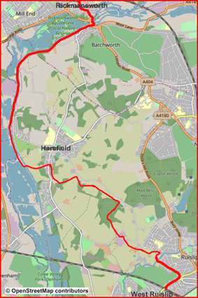
Walk No 11 – from West Ruislip, at the western end of the Central Line, to Rickmansworth
|
Distance |
14.5 km ( 9 miles) |
|
Underfoot |
Footpaths, woodland tracks, towpaths |
|
Outward Journey |
By Central line to West Ruislip - about 35 minutes from Central London |
|
Return |
By Metropolitam Line from Rickmansworth |
|
Points of Interest |
Bayhurst Wood country Park, Grand Union Canal |
|
Refreshments |
Coy carp PH (after 10 km), Cafes and pubs in Rickmansworth |
|
Public Toilets |
At West Ruislip and Rickmansworth Stations |
|
Shortening the Walk |
Buses from Harefield to Uxbridge |
What To Expect From This Walk
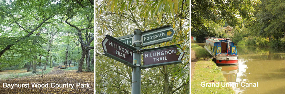
This walk passes through a large tract of open countryside which lies to the north of Ruislip and there many occasions when it is is difficult to believe that you are still within London. Bayhurst Wood Country Park is a good example of this feeling of remoteness. It includes part of Ruislip Woods Nature Reserve is a remnant of the Wildwood that once completely covered England about 8,000 years ago. The woodland contains hornbeam, coppice, oak and beech. In the final partof the walk, there is a 5Km section along the Grand Union Canal which includes a waterside pub
1. Use the pedestrian lights outside West Ruislip Station to cross to the opposite footway of the B466 (Ickenham Road). Turn right for 250m and then turn left into a cul-de-sac, opposite a petrol station, by a large sign for Ruislip Golf Centre. Go ahead past a metal barrier on an asphalt cycle and pedestrian track. Where the asphalt swings right, take a semi-surfaced footpath on the left, signposted R145, going through a kissing gate. Stay on this path, following the white arrows which mark the Hillingdon Trail (HT), ignoring signs to the footpaths R146 and R147.
2. Just after a path comes in diagonally from behind, follow the HT sign left across a footbridge over the River Pinn and enter a field. About half-way up the field, go through a gap in the hedge to your left, where a stile and a marker (HT) are just visible, and turn right on an enclosed path. Walk to the end of the path to reach the gates of Old Clack Farm on your right. Turn left here on a track which becomes a surfaced lane (Tile Kiln Lane). Pass in front of houses, follow the lane through a couple of right turns and reach a T-junction with a larger road. Turn right here and after a few steps, cross the road to a stile in the hedge signposted Public Footpath U41.
The next part of the walk is on paths which are less distinct, but are always marked by signposts, gates and stiles.
3. Cross over the stile and continue straight ahead to go through a rusty wrought-iron gate, which leads into a rough stretch of grassland. Continue to the top right-hand corner of this field and turn right to reach a farm track with some large green barns visible beyond. Turn left on the farm track, with your back to the barns, to enter a field through a double metal gate. You turn right here to walk through two fields, with the hedgerow on your right.
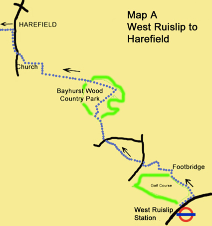
4. At the end of the second field, where more green buildings are visible (this time a small industrial estate), cross a stile, go up a small slope via some dilapidated wooden steps and turn left on an indistinct path, signposted U39. Cross another stile into a field and turn right, still following the footpath signs. Pass a rickety bench to reach a gate onto a track. Go straight over the track to the gate opposite, which takes you into the next field. Walk down the right-hand side of the field towards a faded footpath signpost. At the signpost, bear slightly left across the grass towards a much clearer footpath sign for the U40, next to a gate. Go through the gate onto a farm track. Ignore the faded waymarks on the stile directly opposite. Instead, turn left on the track and join the footpath a little further on by going through a large gap in the fence to your right. Follow the footpath for a short distance to a stile where you emerge onto a road.
This is the end of the less distinct section.
5. Turn briefly left on the road to reach a footpath on the opposite side. Turn right and continue on this path (the U35), ignoring signs for footpath U36. When you reach a fork with a bridleway to the right and a wooden gate ahead, go through the wooden gate into Bayhurst Wood Country Park. Swing left to follow the path along the edge of the woods until you reach a rectangular open space with picnic tables. Cross diagonally to the far side of the rectangle, looking out for a narrow bramble-lined path at the top corner. This path cuts through the undergrowth for about 50m to meet a clear track, where you will see a Hillingdon Trail sign pointing left and right. Turn right here on the Hillingdon Trail and go gently uphill into the woods.
6. Follow this well-defined path, waymarked with blue bridleway signs and white HT arrows, as it drops down past an information board and a wooden hut. Shortly after passing the hut, go through a vehicle barrier to reach a track, where you turn left towards a car park. Swing slightly left through the car park. When you reach the furthest part of the car park area, you will see a clear gap ahead in the car park boundary. Go through this gap and take the path ahead through the woods.
7. Continue walking in this direction. The path may be hard to discern at first due to fallen leaves, but your way is always ahead, with the edge of the wood to your right, with glimpses of the fields beyond. When you come to an HT sign indicating left and straight on, continue straight on, now next to a fence which separates the path from a bridleway, which comes in on your right. Just past an HT information board, go through the fence to join the bridleway. On the next stretch the bridleway and footpath are sometimes separate, in other places together. Continue, always in the same direction, until the path turns left. Go right here through a kissing gate, sign-posted HT. Follow this path as it winds through trees.
8. Go through another kissing gate, still on the Hillingdon Trail, and climb uphill through a large open field with a hedge on your right. In the top right-hand corner, go over two waymarked stiles and enter another large field with a distant footpath sign visible ahead at the far end. With the hedge on your right, walk towards the signpost. Turn left at the signpost to follow the Hillingdon Trail downhill and then continue through woods to reach the churchyard of Harefield Parish Church. Continue with the churchyard wall on your left. Where the wall turns left, follow the HT sign to take the right-hand of two paths. Follow this path till you reach a metal stile which brings you out onto the church access road. Turn right here to walk up to the main road (Church Hill), where you turn right again. Cross over to walk on the footway for 500m through Harefield until you reach an HT sign at Bird Lane (100m after Countess Close, and just before Dovedale Close bus stop).
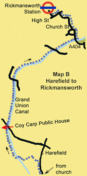
9. Turn left (marked HT) to descend between houses. Cross a residential road and continue downhill. Climb to a junction of paths, where you bear left. A lovely vista with a distant lake now opens up before you. Continue down to the end of the enclosed path and then descend diagonally across a field with the Grand Union Canal below you. The path meets a lane. After a short section of lane walking, cross a canal bridge to reach the towpath. Turn right along the towpath for 750m to reach The Coy Carp pub. After the pub, carry on along the towpath for another 4 km to reach Rickmansworth. Your exit point is the large bridge carrying the A404 traffic over the canal (see Map B).
10. Go under this bridge and climb the steps up to the road. Turn right and walk up to the roundabout. Turn right into Church Street and follow it for 600m until it intersects with the High Street. (The left-hand footway takes a short cut through the churchyard.) Turn left into the High Street, where there are several cafés. After 250m, turn right into Station Road. Continue up to a T-junction where you turn left to reach Rickmansworth Station.
Information On The Things You Will See
The Grand Union Canal (GUC) is 220Km (137 miles) long and stretches from Brentford on the River Thames to Gas Street Basin in Central Birmingham. It has 166 locks. It has “arms” to places such as Slough, Leicester and Northampton and connects with the Oxford Canal at Braunston. It is a 'wide' or 'broad' canal, i.e. its locks are wide enough to accommodate two narrowboats side by side or a single wide barge up to 14 feet (4.3 m) in beam.
Rickmansworth is situated 20 miles northwest of central London and is just inside the M25 motorway. It is the administrative seat of the Three Rivers District Council. The three rivers, the Colne, Chess and Gade, provided water for the watercress trade and power for corn milling, silk weaving, paper making and brewing, all long gone. Other historic activities included leather-tanning, soft drinks, soya processing, laundry, straw-plaiting and stocking production.
Harefield is the home of the famous heart and lung hospital where Professor Magdi Yacoub carried out the first ever live lobe lung transpant in December 1983. By the end of that decade it was the world-leading centre in the world for heart and lung transpants. It is now part of the Royal Brompton & Harefield NHS Foundation Trust which is the largest specialist heart and lung centre in Europe.