- Details
- Hits: 9151
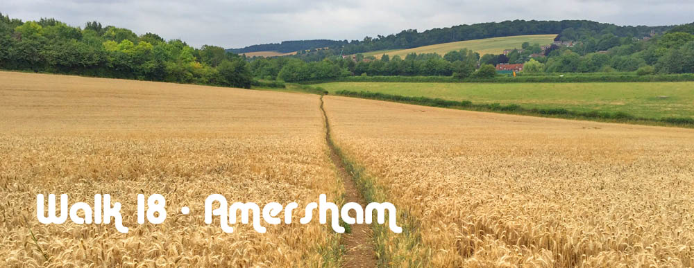
Walk 18 - From Amersham at the Western End of the Metropolitan Line to Beaconsfield
|
Distance8 |
13 km (8 miles) |
|
Underfoot |
Country paths and woodland. Possibly muddy or overgrown in places |
|
Outward Journey |
By Metropolitan Line to Amersham. About 55 minutes from Central London |
|
Return |
By train from Beaconsfield |
|
Points of Interest |
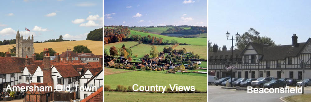
Amersham Old Town, Belonscot Model Village |
|
Refreshments |
Amersham Old Town |
|
Public Toilets |
Amersham Station |
|
Shortening the Walk |
No opportunities |
What To Expect From This Walk
Of all London's tube lines, the Metropolitan Line extends furthest into the countryside, well beyond the boundary of the Metropolis. Consequently this walk is a rural adventure rather than a suburban stroll. The route can be found on OS Explorer Map 172 Chiltern Hills East. Within a mile of the start you arrive at Amersham Old Town. You should take advantage of the refreshment opportunities here, because there are no more en route. After this you are on a variety of paths and byways which lead you into a tract of lonely countryside with only a few farms and farm animals for company. When you enter Hedgemoor Woods there is a wide choice of paths but follow the route directions carefully and you will emerge on a minor road near Seer Green. After some further interesting paths and easy lanes the final stretch leads through woods to Beaconsfield.
Route Directions
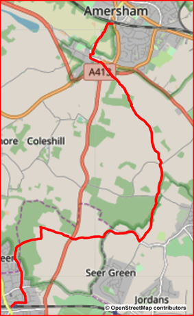
1. Come out of Amersham Station and turn left downhill. Turn left again and go under a railway bridge. Cross the road and take the path that goes between the railway and some houses. After 100m, go diagonally left uphill through Parsonage Wood. Go left again at the top and walk parallel to a road, visible through the trees on your right. Start walking downhill and take a right-hand fork (almost straight on) to emerge from the trees with a pleasant view ahead.
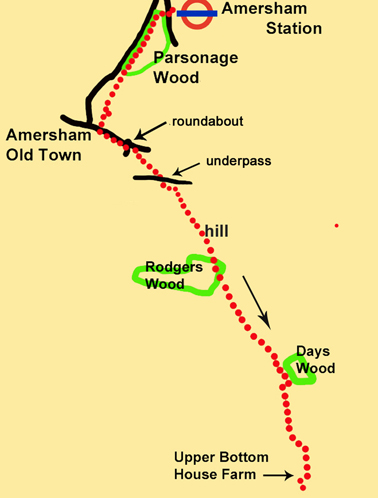
2. Descend on a paved path. When you reach the bottom, walk to the left along a cemetery wall, and turn right to cross a stone bridge over a stream, with a church ahead. Before reaching the church, take the first of two paths on your left which leads you through the Memorial Gardens to reach the high street of Amersham Old Town, with several cafés and pubs. Turn left and take the footway on the right-hand side for 250m to a busy roundabout, which you go straight over. Continue walking on the right-hand footway in the same direction. Go past the first house and turn right at the gate to Bury Farm, on a waymarked path. Follow this path as it swings left and goes into a field.
3. Follow a path across the field to the far right corner and go through an underpass. After leaving the underpass, continue for about 150m and then turn right uphill through a metal gate. Turn left and ascend diagonally through two fields, following the path towards the corner of a wood (Rodgers Wood). Enter the woods and emerge soon from the trees to continue ahead in the same direction.
4. Walk to the far hedge-line, where there is a marker post. Turn left and follow the hedge towards a small wood (Days Wood). 100m before you reach the wood, go through a gap on your right, between two wooden posts, and then turn left, so that you are now walking with the hedge on your left. Continue past the wood.
5. When you reach the end of the field, turn right and walk for 40m beside a short length of fence on your left. Where the fence ends, take the path going diagonally left across the field, as indicated by a faded yellow arrow on the final fence post. Walk for 400m to the distant hedge line. Enter another field through a metal gate, turn right and walk around the field edge to the far right-hand corner.
6. Descend towards Upper Bottom House Farm which lies ahead of you. Pass through the farmyard via a metal gate and turn right on a lane. After 75m turn left and follow a track which ascends the opposite side of the valley. Ignore a left fork. When you reach a house near the top, turn right and continue with the wall of the house on your right. 100m after the wall finishes, go through a kissing gate on your right and walk ahead to reach a road. Cross over the road and enter Hodgemoor Woods.
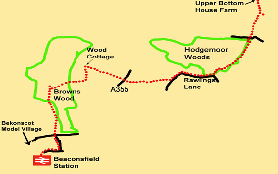
7. Hodgemoor Woods is an extensive area of woodland, but your route always stays just inside its left-hand perimeter. 50m after entering the woods, turn left on a track which comes in from the right and follow it as it curves right. Very soon the track turns left, You, however, go straight ahead through a waymarked gap in a fence, on a clear path into the woods. You stay on this path all the way through the woods. After 100m keep left at a fork but stay within the woods. After another 200m, ignore a left turn (with a marker post) which goes towards a hollow tree. Instead, keep ahead on the main path and follow it for another 700m as it twists and turns amongst the trees. As a guide, the edge of the wood is always clearly visible to your left.
8. After a while you can see that you are walking parallel to paddocks which are separated from the trees by a wooden fence. Finally, go past a wooden barrier, ignore two woodland tracks coming in from your right, and continue ahead to reach Rawlings Lane. Turn right and follow the lane. After 350m, ignore a sign for the Chilterns Heritage Trail at Rawlings Farm and continue on the lane, past Widmer Farm, to a junction with a track coming in from the right. Turn sharp left here and continue on the lane. After 250m look for a signed footpath going right. The first part of the path might be overgrown, but after 250m any nettles and briars subside and the path opens out and descends to become a broad woodland track, which swings right beside a fence. Follow it out to a main road (the A355).
9. Cross the road and enter the lane directly opposite, past a house on the corner which has the name Whites Hill on its garden wall. Walk up this lane for 800m to Wood Cottage, where there is a signposted junction of paths. Turn left and pass to the left of the cottage. After 125m leave the track and go ahead to the right of some large conifers on a grassy path. Where the trees end, turn right and walk across a field towards some woods.
10. Enter the woods and continue in the same direction (west) along a generally clear but sometimes muddy path until you reach a crossing track with a marker post. Turn left and walk on until you see a tall wooden fence. You have now reached the outlying houses of Beaconsfield. Ignore a sign pointing to the right. Go straight ahead for about 850m, with the fence on your right (and later on your left as well) to emerge on a suburban road. This is Ledborough Lane. If you wish to visit Bekonscot Model Village, you should turn right here. To continue to the railway station, cross the road and go ahead into Wilton Road. Follow it as it dog-legs to the left and then turn right at a T-junction onto Caledon Road. Follow this road to its end, then swing left and descend on a footpath to reach Beaconsfield Station.
Amersham is a market town in the Chiltern Hills, Buckinghamshire 27 miles (43Km) north west of London. There are two distinct settlements : Old Amersham set in the valley of the River Misbourne and Amersham-on-the-Hill. This latter area of the town was referred to as Amersham Common until the arrival of the Metropolitan Railwayin1892. After this, the of the growth of the town accelerated and It is now known locally as "Amersham town" or the "New Town"
Amersham Old Town contains the 13thC parish church of St Mary’s and several old pubs and coaching Inns. Early trade at Amersham Market was in local grain, much of which was sold to London merchants. During the 17th century and 18th century a key industry in the town was brewing
Beaconfield Model Village (Bekonscot) was created in the 1920s by Roland Callingham and portrays images of England dating back to the 1930s. Bekonscot has been run by the Church Army since 1978 and has been visited by more than 14 million people. Callingham developed his miniature world as an addition to his large back garden portraying rural England at the time. He named the village 'Bekonscot' after Beaconsfield and Ascot where he previously lived. It was not conceived as a visitor attraction but as a plaything to entertain him and his guests. It was only after 1930 that its existence became widely known, catching the imagination of the press and public alike. It is open from April until October each year, 7 days a week. If you want to include it in your walk please visit http://www.bekonscot.co.uk/


- Details
- Hits: 8247
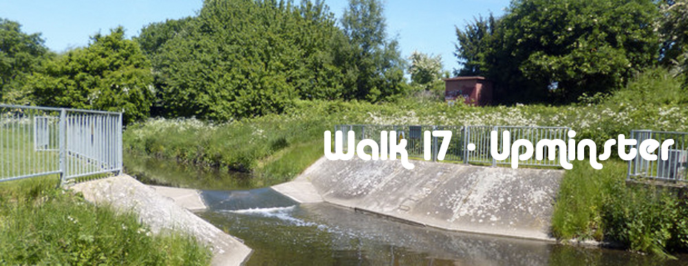
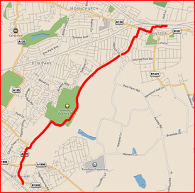
Walk 17 - From Upminster, at the Eastern End of the District Line, to Rainham
|
Distance8 |
8 km (5 miles) |
|
Underfoot |
Good paths throughout |
|
Outward Journey |
By District Line to Upminster. About 55 minutes from Central London |
|
Return |
By train from Rainham |
|
Points of Interest |
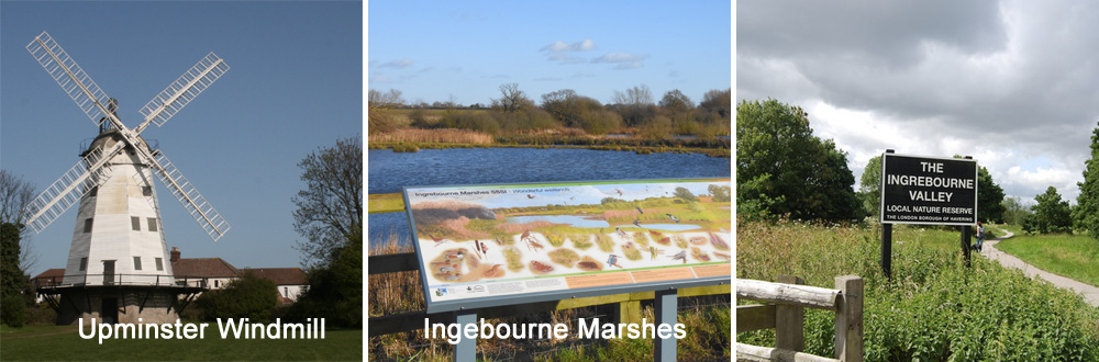
Upminster Windmill, Ingebourne Valley |
|
Refreshments |
Visitor Centre half way, Albion pub near the end |
|
Public Toilets |
At Upminster Station |
|
Shortening the Walk |
No opportunities |
What to Expect from This Walk
This is an easy walk on good paths through a ribbon of countryside by the side of the River Ingrebourne. It begins with a stretch of road walking which is enhanced by passing the attractive Upminster Windmill. Visits are possible at certain times. There is a pub of the same name just a bit further on. Once you reach the river, routefinding is very straightforward, particularly so since you are also following green "London Loop" roundels. At the end you may wish to visit Rainham Village before catching your train home.
Route Directions
1. Leave Upminster station and walk up Station Approach to the main road. Turn left, cross over, turn right into Branfill Road and follow it as it turns left. Turn right into Highview Gardens and then almost immediately left into Cranbourne Gardens. You may be able to see the windmill between the houses. To reach it, go to the bottom of the road and turn right along St Mary’s Lane (A124). The windmill is on your right. At the time of writing, it was closed for restoration, but due to re-open in 2020.
2. Continue to the bottom of the hill and turn left into Bridge Avenue. This road has no street sign, but you can identify it by the London Loop sign on the opposite side of the A124, together with a large sign for Hornchurch Sports Stadium, both pointing your way. Walk along Bridge Avenue for 450m and then turn right between hedges, as indicated by another London Loop sign. The path leads you briefly towards Hornchurch Football Stadium but turns left before reaching the gates and passes a car park. Keep left and climb a small slope. You are now on a path which will lead you all the way to Rainham. Follow the path, which takes you back to the river bank, and continue in the same direction as before. You pass a sign for the Ingrebourne Valley.
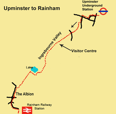
3. Go ahead, ignoring all turnings to the left or right, and reach a play area and a visitor centre with a café, toilets and a gift shop. Carry on until you reach a signpost which gives you a choice of route to a lake. Take the left-hand path. Descending slightly, you come to the viewing area for Ingrebourne Marshes with an information panel. Continue on the path and turn right at a corner. Continue on the path to reach a lake on your right. At the end of the lake, turn right and walk for about 350m to reach a walled house (Albyns Farm) on your right.
4. Shortly afterwards, turn left on a car-wide track. When the track ends, go right between some wooden posts and then turn left to continue in the same direction as before. After another 500m you can see a lake on your left and a car park ahead, with a road beyond it. Pass to the right of the car park and walk out to the road. Turn left and after 300m reach The Albion pub. After the pub, continue to a major roundabout and use the pedestrian lights to continue ahead. Cross the River Ingrebourne via Red Bridge. This is the last time you will see the river on this walk. Cross the access road to a large supermarket and turn left on Bridge Road. Follow it past a church to reach Rainham Station on your right
Information on Things You Will See
Upminster Windmill was built in 1803 and was formerly known as Abraham’s Mill. The mill has a four-storey smock on a single-storey brick base. It is 15.8m high (52 feet) It has a boat-shaped cap with a gallery. Four patent sails are carried on a cast-iron windshaft. In 2004 the Upminster Windmill Preservation Trust was granted a 35-year lease on the mill. Subsequently it has been restored and is a museum open to the public at selected times
The River Ingrebourne rises near Brentford in Essex and flows for 43 Kilometres (27 miles) in a south westerly direction to enter the River Thames near Rainham. It passes under the M25 near Junction 28 and skirts Harold Hill before passing between the suburbs of Upminster and Hornchurch. Ingrebourne Marshes is a site of special scientific interest due the diversity of birds and other wildlife in the extensive beds of wetland reeds. The Ingrebourne Valley is a local nature reserve.
Rainham is a suburban town on the outskirts of east London, part of the London Borough of Havering, historically part of the county of Essex. It is 22Km (14 miles) east of Charing Cross. Rainham is located in part of London that is susceptible to flooding. It is mostly situated on gravel and a tidal section of the River Ingrebourne forms its western boundary. The nearby marshlands along the boundary of the River Thames are only about 1.5m above sea level. The high ground you can see to the south east is a major landfill site and a destination for London’s waste which is brought downriver by barge.
- Details
- Hits: 9062
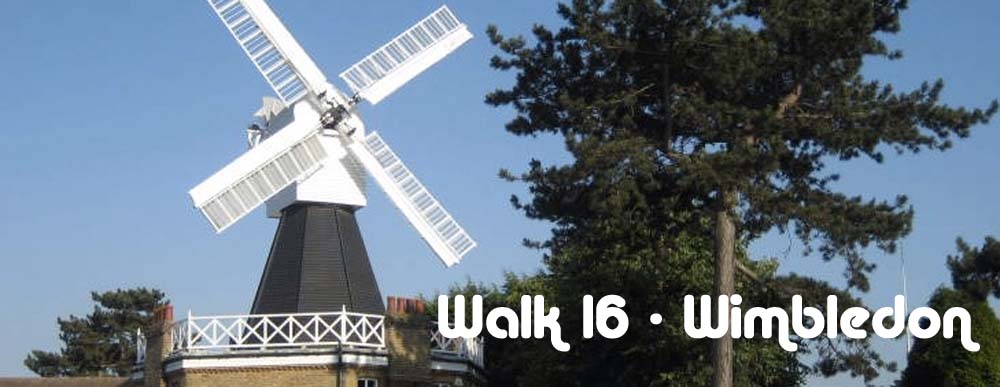
Walk 16 - From Wimbledon, at the South-Western End of the District Line, to Putney
|
Distance |
7.5 km (4.5 miles) |
|
Underfoot |
Paved surfaces and footpaths |
|
Outward Journey |
By District Line to Wimbledon or train from Waterloo - about 30 minutes from Central Londonth |
|
Return |
By train from Putney |
|
Points of Interest |
Wimbledon Common, Wimbledon Windmill, Putney Heath |
|
Refreshments |
Pubs & cafes in Wimbledon Village and Putney, Windmill Cafe on the Common. Green Man Pub at top of Putney Hill |
|
Public Toilets |
At Wimbledon Station and at Windmill Cafe |
|
Shortening the Walk |
You can catch a bus down Putney Hill |
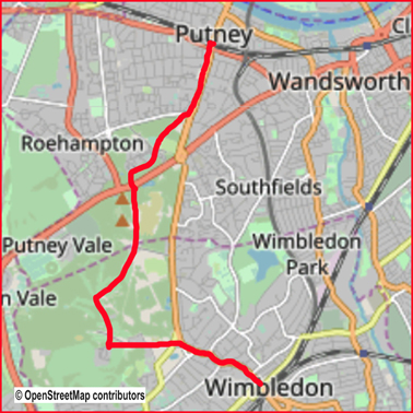
What to Expect From This Walk This is an easy walk exploring an attractive corner of south west London. Wimbledon Common and Putney Heath are recreational areas with extensive woodland and large areas of open heath. The walk starts with a gentle climb from Wimbledon Station to Wimbledon Village. The village has many shops, cafes and pubs where you can take a break before setting out across the common. There is another cafe in the centre of the common beneath the sails of the the windmill. After passing the windmill you gain access to Putney Heath via an underpass beneath the busy A3. The Heath has a distinctly different feel to the common. It has less open spaces but a pleasant mix of woodland and ponds. You will emerge from the Heath at the Green Man PH. Then it is simply downhill for 1Km to the end of the walk. Putney is another bustling high street with all facilties. Instead of going directly to the station you may like to extend the walk slightly to see Putney riverside which hosts the Oxford v Cambridge Boat Race each year. Simply continue straight ahead for 500m.
The Route
1. Wimbledon Station has two exits. To find the exit for this walk, turn right after climbing the steps from the platform and exit the station via the main concourse. Cross the road and turn right. Cross two junctions at the traffic lights. Follow the left-hand footway of Wimbledon Hill Road uphill for 1 km. If you prefer to avoid this part of the walk you can catch the no. 93 bus from Stop R for two stops to Marryat Road, opposite the Rose & Crown pub, and then pick up the walk route at the war memorial. Otherwise, walk up the road which brings you into Wimbledon Village with its cafés, shops and pubs.

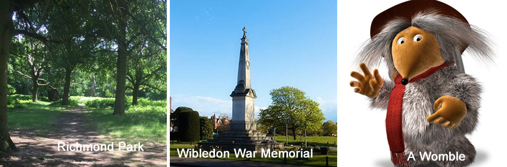
2. At the first roundabout the road swings to the right. At the second roundabout it swings to the left. Continue to the end of the village, keeping to the left-hand footway. Wimbledon Common is now on your left and ahead of you is a war memorial in a triangle of land between roads. Walk right up to the memorial and then go around it to continue in the same direction. After a few steps, cross a small road and go ahead on a sandy track (which may be muddy after rain) which bends to the right. You follow this track for 140m to reach another road. Cross the road and enter the track directly opposite, which takes you straight ahead into the woods. It is separated into a bridleway on the right and a footpath on the left.
3. Ignore all turnings to the left and the right including a wide path after 500m which cuts diagonally across. 300m after the diagonal crossing path, reach a major crossing track. Turn right along this crossing track, which immediately curves gently to the right. Continue for 300m until you see a golf course on your left. Leave the track and walk along the left-hand edge of the golf course, taking care not to inconvenience any golfers. You can now see a windmill to your right, in a cluster of other buildings. Walk between the golf fairways towards the left-hand corner of the buildings. Turn left here and then immediately right to walk around the perimeter. At another corner, turn right to reach the Windmill Café and car park.
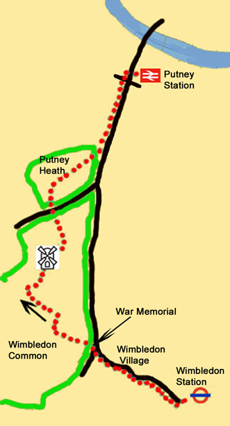
4. With the café at your back, turn right and walk through the car park. At the end of the car park, you will see two footpaths ahead of you. Do not take the right-hand path, which is signed Capital Ring. Instead, take the narrower left-hand path, which leads towards some trees, about 100m distant. Pass through the trees, arrive at a junction of paths and turn left on a broad track. Walk for 300m and where the track divides, take the left-hand fork. In another 300m go through an underpass. You have now entered Putney Heath.
5. About 30m after the underpass, turn right on a narrow path and follow it for 150m to reach a pond at a junction of paths. Go straight ahead along the top of the pond for 30m and then turn left at its far corner, so that you are still walking with the pond on your left. 70m beyond the end of the pond, reach a broad crossing path and turn sharp right. You will see houses and a vehicle barrier ahead. 50m before reaching the barrier, turn left on a clear path, which goes into the wood and becomes a broader track. Follow this for the next 450m, ignoring all paths to the left and right. At first there is a wooden fence on the right and later a stone wall.
6. Cross a small road and enter a large grassy area which contains a cricket pitch. Follow the left-hand perimeter until you reach the top left-hand corner. Turn left here on a track which you follow for 250m to reach a five-way junction. Take the second path on the right, which is an earth track (rather than a grass track). Walk for another 250m, ignoring all crossing tracks, and emerge at the corner of Putney Heath, with Putney Hill (the A219) on your right. The Green Man pub (out of sight initially) is ahead on your left, near the bus stops. From here you can catch a bus no. 14, 37, 93 or 85 down the hill to Putney High Street. Otherwise, simply walk down the hill for 900m to reach Putney Station.
7. To extend the walk to Putney Bridge, the starting point for the annual Oxford and Cambridge Boat Race, continue down the High Street for a further 500m until you reach the riverside. Putney Bridge Underground Station can be reached by crossing the River Thames and then turning right down some steps
Information on things You Will See
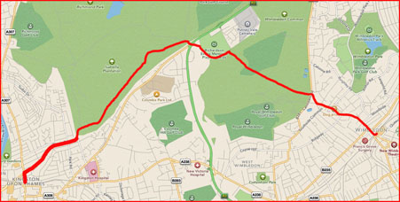
Wimbledon Common is a large open space of forest and heathland totaling about 1,150 acres. It comprises three area : Wimbledon Common, Putney Heath and Putney Lower Common. It is protected from being enclosed or built upon by an act of parliament which was passed in 1871. It is a site of Special Scientic Interest. The common is maintained for the benefit of the general public for informal recreation, and for the preservation of natural flora and fauna. It is the notional home of the Wombles who were created by Elizabeth Beresford and had their own TV show and pop group. It was also one of the locations in H.G. Wells The War of the Worlds.
Putney Heath is comprised of woodland and a series of open glades, including "The Frying Pan", a popular area for picnicking. The Heath was once described as ‘a wide expanse of open ground, uncultivated, where large crowds could assemble, horses could be raced, troops could be exercised and reviewed, duels could be fought and highwaymen preyed on the increasing traffic along the Portsmouth Road.
The Green Man Pub Dating back to somewhere around 1700, the Green Man on Putney Heath stands on an old duelling spot. The pub was often the refuge for the surviving contestants. It is also notorious for its highwaymen. Rumour has it that Dick Turpin once stashed his guns in the upstairs room whilst other robbers watched their intended victims taking refreshment in the pub before going after them once they resumed their journey across the heath.
- Details
- Hits: 7968
Walk 15 From Wimbledon, at the South-Western End of the District Line, to Kingston.
|
Distance |
9 km (5.5 miles) |
|
Underfoot |
Good paths and paved surfaces |
|
Outward Journey |
District Line to Wimbledon or train from Waterloo - about 30 minutes from Central London |
|
Return |
By train from Kingston |
|
Points of Interest |
Wimbledon Common, Richmond Park |
|
Refreshments |
Pubs and cafes at Wimbledon Village, refreshment kiosk in Richmond Park near Robin Hood Gate |
|
Public Toilets |
At Wimbledon Station and Richmond Park (Kingston Gate) |
|
Shortening the Walk |
Catch the 265 bus from Robi Hood Gate to Putney Station |
What to Expect From This Walk
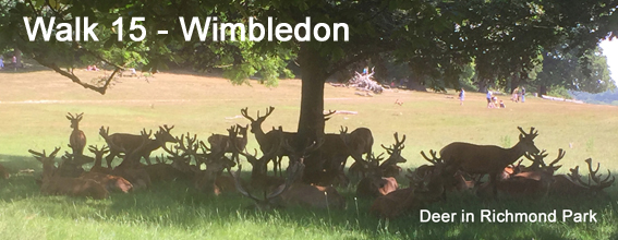
 This walk explores Wimbledon Common and Richmond Park. After a gentle climb to Wimbledon Village, you set out across Wimbledon Common, an extensive area of woodland. The path cuts through the Common to Robin Hood Way (the A3), where you will find one of the main gates to Richmond Park. Once inside the park, you walk through attractive woodlands near the park’s perimeter and will hopefully see some of its 600 red and fallow deer. Kingston upon Thames is an ancient borough where Saxon kings were once crowned. It is now a lively retail centre with an attractive riverfront.
1. Wimbledon Station has two exits. To find the exit for this walk, turn right after climbing the steps from the platform and exit the station via the main concourse. Cross the road and turn right. Cross two junctions at the traffic lights. Follow the left-hand footway of Wimbledon Hill Road uphill for 1 km. If you prefer to avoid this part of the walk, you can catch the no. 93 bus from Stop R for two stops to Marryat Road, opposite the Rose & Crown Pub, and pick up the route at the war memorial. Otherwise, continue up the road, which brings you into Wimbledon Village with its many cafés, shops and pubs.
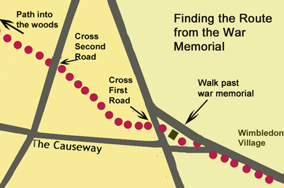
2. At the first roundabout, the road swings to the right. At the second round-about, it swings to the left. Continue to the end of the village, using the left-hand footway. Wimbledon Common is now on your left and ahead of you is a war memorial in a triangle of land between roads. Walk right up to the memorial and then go around it to continue in the same direction. After a few steps, cross a small road and go ahead on a sandy track (may be very muddy after rain) which bends to the right. Follow this track for 140m to reach another road. Cross the road and continue on the track directly opposite, which takes you straight ahead into the woods. The track is divided here into a bridleway on the right and a footpath on the left.
3. Ignore all turnings to the left and right, including a wide path after 500m, which cuts diagonally across your path. 300m after the diagonal crossing path, you reach another major crossing track. Go straight ahead here and ahead again at the next crossing track after a further 200m. You continue ahead for 700m, ignoring all paths to the left and the right, until you reach a fork. Take the right-hand fork to pass a golf green on your right and a bench on your left.
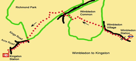
4. The path starts to descend. Continue ahead and after another 500m follow a dog-leg right and left to carry on in the same direction. A large open space, which contains playing fields, is now visible through the trees on your right. Follow the path at across a brick bridge and walk towards a busy road to reach the A3 at a roundabout.
5. Cross at the traffic lights and go ahead to enter Richmond Park through the Robin Hood Gate. As you enter the park there is a car park on your right and a vehicle roundabout ahead (beyond which there is usually a refreshment kiosk). 40m before reaching the round-about, turn left on a clear path among the trees and bracken. You are now walking in a broad corridor of parkland between the boundary wall of the park on your left and a road on your right. Continue for 3 km on this path to reach the Kingston Gate of Richmond Park.
6. Leave the park and turn right onto Kings Road. After 500m the road swings right. At this point, turn left into Acre Road and follow it for another 700m to reach a main road. Turn left here and walk 250m to reach Kingston Station, with mainline trains to London Waterloo.
Information on Things You will See
Wimbledon is an area of London 12Km (7 miles) south-west of Charing Cross in the London Borough of Merton. The area is split into two sections known as the "village" on higher ground near the Common and the "town" centred on the railway station which was opened in 1838. Wimbledon is the home of the world famous tennis championships which are held during the first two weeks of July every year.
Wimbledon Common is a large open space of forest and heathland totaling about 1,150 acres. It comprises three area : Wimbledon Common, Putney Heath and Putney Lower Common. It is protected from being enclosed or built upon by an act of parliament which was passed in 1871. It is a site of Special Scientic Interest. The common is maintained for the benefit of the general public for informal recreation, and for the preservation of natural flora and fauna. It is the notional home of the Wombles who were created by Elizabeth Beresford and had their own TV show and pop group. It was also one of the locations in H.G. Wells The War of the Worlds.
Richmond Park, was created by Charles I in the 17th century as a deer park. At 2,360 acres it is the largest of London's Royal Parks and is of national and international importance for wildlife conservation. It is a place of many walkers, cyclists and horse riders and is home to roughly 630 red and fallow deer which roam freely through the park. Richmond Park is a top UK site for ancient trees, particularly oaks, which have historic and wildlife importance.