- Details
- Hits: 9672
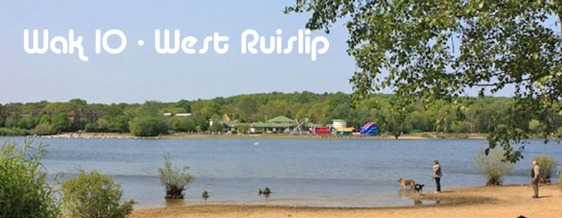
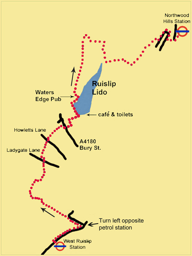
Walk No 10 – From West Ruislip, at the western end of the Central Line, to Northwood Hills
|
Distance |
7 km (4.5 miles) |
|
Underfoot |
Mostly paved surfaces. Some country paths |
|
Outward Journey |
By Central Line to West ruislip- about 35 minutes from Central London |
|
Return |
By Metropolitan Line from Northwood Hills |
|
Points of Interest |
Olympic Park. Victoria Park, Regent's Canal |
|
Refreshments |
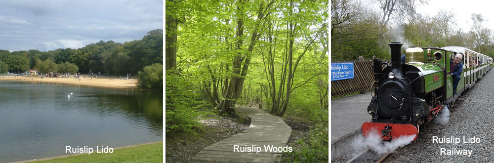
Lakeside Cafe and waters Edge Pub at Ruislip Lido |
Public Toilets |
West Ruislip Station. Ruislip Lido |
Shortening the Walk |
Catch an H13 bus from the lido to Pinner or Ruislip Stations |
What To Expect From This Walk
Within a short distance of leaving West Ruislip Station this walk enters quiet countryside and crosses the River Pinn to follow a series of paths behind houses and schools. Later, the walk goes through woodland to reach Ruislip Lido, with its artificial beach, café and pub. The route continues north through open countryside and then leads into Ruislip Woods. Towards the end of the walk, you climb up Haste Hill before reaching Northwood Hills Station.
Route Directions
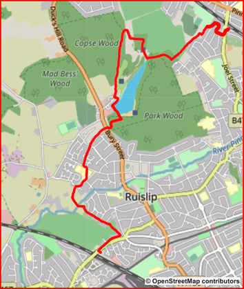
1. Use the pedestrian lights outside West Ruislip Station to cross to the opposite footway of the B466 (Ickenham Road). Turn right for 250m and then turn left opposite a petrol station into a cul-de-sac, by a sign for Ruislip Golf Centre. Go ahead
past a metal barrier on an asphalt cycle and pedestrian track. Where the asphalt path turns right, take a semi-surfaced footpath on the left, signposted R145, going through a kissing gate. Stay on this path, following the white arrows which mark the Hillingdon Trail (HT) and ignoring signs to the footpaths R146 and R147. Just after a path comes in diagonally from behind, follow the HT sign left across a footbridge over the River Pinn and walk into a field. About half-way up the field, go through a gap in the hedge on your left, where a stile and a waymark (HT) are just visible, and turn right on an enclosed path. Walk to the end of this path and reach the gates of Old Clack Farm on your right, with a wall ahead.
2. Climb over the stile in the right-hand corner of the wall and go down the right-hand side of a field. Turn right at a Hillingdon Trail signpost and cross a footbridge. Go through a gate and turn left to walk behind houses and a school. Turn left into Ladygate Lane, walk for 100m, turn right, signed HT, still continuing in the same direction as previously. Continue to Wheelers Drive, which leads into Wallington Close. Keep walking in the same direction and enter a footpath again.
3. Cross Howletts Lane and continue ahead to the right of some shops. This section is a grassy strip between houses on the left and trees on the right. After 300m go straight ahead across an open grassy space to reach Bury Street (the A4180). Turn right and cross the road, just after a bus stop. Go past a vehicle barrier onto a woodland track. At the first crossing track, turn left and follow this path as it veers right to follow a fence until you reach the metal gate to Ruislip Lido. Go through the gate and enter the Lido. You should turn right at this point if you wish to visit the beach and the Lakeside Café.
4. To continue, go straight ahead with the water on your right. At the far corner of the lake, turn right and pass a children’s play area. Just before the Waters Edge pub, turn left to reach a road. To your right you will see two car park entrances, with a gate between them. Go through the gate signposted HT and Footpath R59 and continue ahead on the clear path. At the first wooden fingerpost carry straight on.
5. The path rises between trees and continues in the same direction. About 1 km from the gate, a path comes in from the right. Ignore this and carry straight on. A little further on, there is a fork where you can see a pond ahead. Take the right-hand path, and cross over a footbridge and a stile. Turn right on Footpath 37, which goes along the edge of some trees, with a golf course on your left. Emerge from the trees facing the golf course but do not take the path ahead. Instead, turn sharp right past an old concrete bunker and follow a clear path through trees, with a fence on your right.
6. The path turns left here and there is no longer any cover between you and the golf course. After 200m, the path makes a sharp right turn and follows the line of trees. You reach a point where you can see the tracks of a miniature railway through a black metal fence on your right. Continue beside the fence for another 100m to a junction of paths. You then turn left on a footpath and walk uphill through the wood.
7. At the top of the hill, turn left and go through the first metal gate. Continue on a good path and ignore any options to turn to the left or the right. The view opens up over to your left. After about 600m the path becomes narrower and then descends through a meadow to reach a sports field. Turn right here and take the track which leads between houses to bring you out onto a residential road (Highland Road). Turn left and walk around two right-hand bends to find another footpath on your left, which leads you out to the main road near Northwood Hills Station.
Information on Things You Will See
Ruislip Lido is a reservoir with an artificial beach. It was built as a feeder reservoir for the Grand Union Canal which is located several miles to the west. The Grand Junction Canal Company, as it was then called, purchased about 90 acres of land and the valley that the land covered was then dammed and flooded.The reservoir was opened on 5 December 1811 but the link to the canal did not fulfil its intended purpose, since the water became polluted by the land and was eventually stopped as a feeder in 1851. From 1950 - 1980 the Lido was in its heyday as a water-based recreation facility. The lake received thousands of visitors each summer, but in the 1970s a large increase in admission charges meant that people stopped coming and the Lido fell into a state of disrepair. It has only recently been returned to public use for boating and swimming, thanks to a project set up by the London Borough of Hillingdon. Surrounded by Ruislip Woods, London's First National Nature Reserve, the Lido remains a pleasant place to walk. On several occasions it has been used as a film set, notably for the sinking of the Titanic in A Night to Remember (1958) and in Cliff Richard’s film The Young Ones (1961).
Northwood Hills The name "Northwood" apparently comes from "northwode" meaning the northern wood. It is an elevated urban area in the London Borough of Hillingdon and adjoins Ruislip Woods Nature Reserve. It also has a northern border with Hertfordshire. It is reputedly the location used for filming the 1970s BBC TV series "The Good Life".


- Details
- Hits: 8950
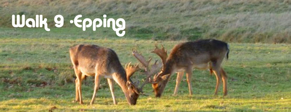
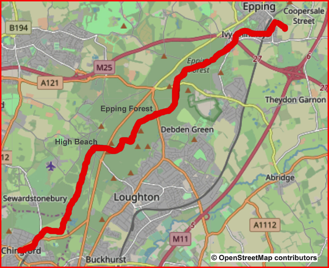
Walk No 9 - From Epping, at the Eastern End of the Central Line, through Epping Forest to Chingford
|
Distance |
15 km (9.5 miles) |
|
Underfoot |
Mostly woodland tracks |
|
Outward Journey |
By Central Line to Epping - about 45 minutes from Central London |
|
Return |
Overground from Chingford . (Connects with the Victoria Line at Walthamstow Central) |
|
Points of Interest |
Epping Forest, High Beach, Queen Elizabeth's Hunting Lodge |
|
Refreshments |
Two pubs en route. Refreshment kisk and cafe at High Beach, Butler's retreat cafe near the end |
|
Public Toilets |
At Eping Underground station and High Beach |
|
Shortening the Walk |
Epping Forest is poorly served by public transport. You could arrange for a taxi to meet you at High Beach (Kings Oak Pub) after 12 km. |
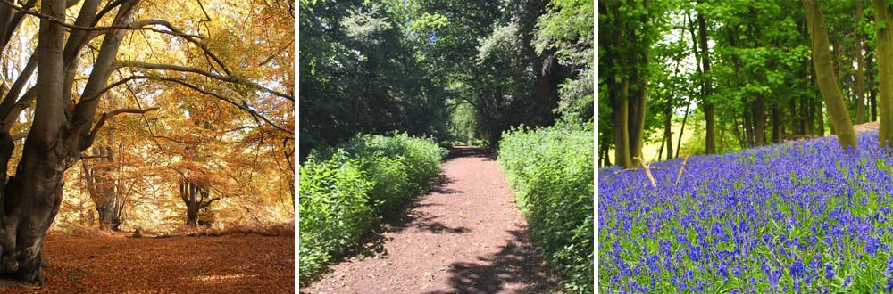
Photos of Epping Forest Through the Seasons
What To Expect From this Walk
This is a walk designed to show off the best of Epping Forest. It traverses the forest from north to south on paths which are accessible and easy to follow. The forest lies to the east of London on a ridge between the River Lea and the River Roding. It is an area of ancient woodland and a former royal forest, now managed by the City of London Corporation. It covers an area of about 6,000 acres and stretches between Epping in the north and Forest Gate in the south. It is approximately 19 km long but no more than 4 km wide from east to west. The age of the forest and the range of habitats which it contains make it a valuable area for wildlife. This walk shows off the many different aspects of Epping Forest from deep woodland and forest glades to open pastures and grassy meadows. It traverses the forest from north to south.
Route Directions
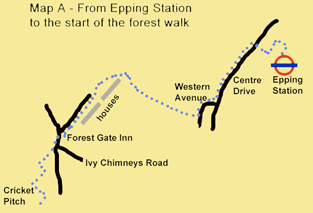
1. Epping Station to the forest (Map A) Turn right out of the station. On the opposite side of the road you will see the entrance to the station car park. Cross over and take the footpath which runs between fences down the right-hand side of the car park. Follow this enclosed path as it turns left and then right. Ascend a flight of steps to reach a residential road (Centre Drive). Turn left and walk for 300m. Just before a small open area of grass, turn right into Western Avenue, which swings to the left. A wide view opens up before you, including a sight of the M25 motorway. Turn right onto a public bridleway at a concrete fingerpost.
2. Follow this path uphill, ignoring a waymarked path to the right and other side paths. You come to an open area of grass. Pass a wooden bench at the top and follow the path to cross a surfaced drive. Turn left to follow an unsurfaced track (Bell Common) with houses on your left. Join a surfaced road coming in from the right. Continue in the same direction along this road until you reach a junction by the Forest Gate Inn. Turn left here, along Theydon Road. When you reach the junction with Ivy Chimneys Road coming in from the left, cross Theydon Road towards the driveway of a house. As you face the drive-way gate, look for a narrow path to your left, at the entrance to the drive, by a lamp post.
3. Follow this path diagonally into the trees until you emerge onto an open grassy area. You are now right above the M25, which runs in a tunnel below you. Cross the grass and turn right on a path coming in from the left. You will see a cricket pitch ahead but before you reach it, turn left onto a path which leads into the trees and up to a ‘roundabout’ of paths, where you continue in the same direction on a broad forest track, soon passing a yellow waymark arrow.

4. To High Beach (Map B) Follow this waymarked track for 2 km, ignoring all turnings to left and right. (After 1.5 km look out for a sign to your right for a short detour to the site of Ambresbury Banks ancient earthworks.) You then reach a road (the B172). Cross the road to the Jack’s Hill information board, and take the waymarked track through a vehicle barrier, slightly to the right beyond the board. After 500m ignore a small yellow waymarked path to the left. 200m later (700m from Jack’s Hill) turn right at a junction onto an unmarked track. This track broadens as it descends and then climbs to reach a small car park (Broadstrood). Stay on the path to the left of the car park to reach the A121.
5. Cross the road with care and take the track opposite, past a vehicle barrier. After a level start the track begins to descend. At the bottom of the hill it swings to the right, then climbs in a series of stages before a final steeper stretch. The track then levels out. After about 200m, at the first junction, turn right to join a broad track, by a bracken-filled triangle. You follow this track to reach a car park on Epping New Road (the A104). Cross over with care and go through a gate to take the track opposite, which swings to the left. Follow this track, ignoring small paths to the left and right, until you reach a T-junction. Turn right here and then continue straight ahead for 250m to reach the road at High Beach, with a large car park over to your left. Cross the road and go left past a refreshment kiosk, to walk along the open grass area with good views to the north. To your left is the entrance to the Epping Forest Visitor Centre. Cross over here for the public toilets and the Kings Oak café and pub.
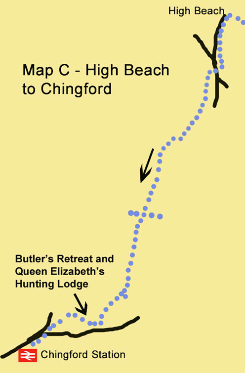
6. To Chingford (Map C) Walk along the road past the Kings Oak. Pass a large pond on the right, and a wooden fence on your left. Where the fence ends, just after you have passed the entrance to a house, take the narrow path to the left which leads into the trees by a small brick building. The path runs parallel to, and never far from, the road. It eventually leads you back to join the road by a vehicle barrier, where a wider path comes in from the left. (A short detour here down the road to the left leads to a popular roadside café.)
7. Cross the road, and take the track opposite, but slightly to the right, past another vehicle barrier. You follow this track for more than 3 km, all the way to Chingford, initially following the yellow and orange waymark arrows. After 800m the path follows a dog-leg right and left. After another 500m, it continues ahead across a junction with other tracks. Later, ignore a yellow arrow pointing to the right and continue to follow the orange arrow pointing straight ahead. When you eventually reach a point where the main track swings left, take the broad grassy path straight ahead. At a clearing where a path comes in from the left, go straight on and slightly uphill towards the white weatherboarded building just visible ahead. This is Butler’s Retreat café.
8. Just before an impressive restored drinking fountain, follow the fingerpost sign right towards Queen Elizabeth’s Hunting Lodge. Turn right when you reach the hedge enclosing the Lodge car park and go down the grassy slope on a waymarked path towards a small bridge. Do not cross the bridge but turn left along a clear path, which leads you straight to Chingford. When you reach the main road, cross at the traffic island and turn right. Chingford Overground Station, with trains to Liverpool Street, is on your left, just beyond the bus station. You can change to the Victoria Line at Walthamstow Central.
Information on Things You Will See
High Beach was the first British venue for motorcycle speedway and opened in February 1928. The track, which was behind The Kings Oak public house, drew large crowds. It was closed when a swimming pool was added to the pub's grounds after the Second World War. The remains of the track are still visible, in the grounds of the Epping Forest Field Centre behind the King's Oak.
Queen Elizabeth's Hunting Lodge was once known as the Great Standing. In Tudor times Henry VIII often hunted in the forest and in 1543 he commissioned a building from which to view the chase at Chingford. The building was renovated in 1589 for Queen Elizabeth I. The Lodge is open to visitors from Tuesday to Sunday all year round.
- Details
- Hits: 10260
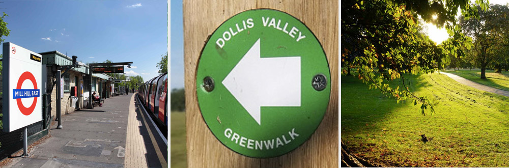
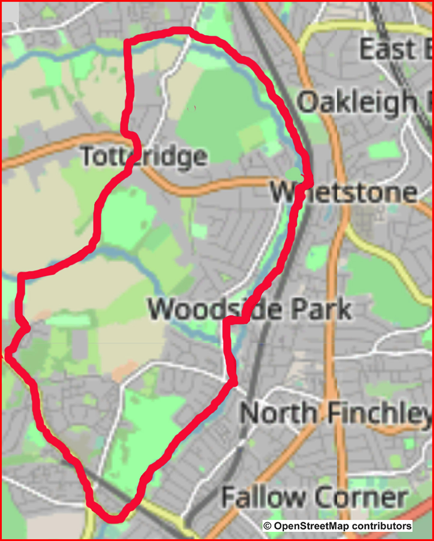
Walk No 7 – A Circular Walk From Mill Hill East a terminus point on the Northern Line
|
Distance |
12.5 km (8 miles) |
|
Underfoot |
Mostly paved surfaces. One section near the end may be muddy |
|
Outward Journey |
By Northern Line to Mill Hill East (changing at Finchley Central) - about 25 minutes from Central London |
|
Return |
By outward route |
|
Points of Interest |
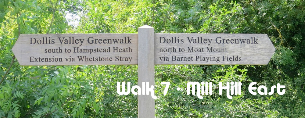
Dollis Valley Greenwalk |
|
Refreshments |
Cafes at Argyle Road (after 2.5 km) |
|
Public Toilets |
At Finchley Central (but none at Mill Hill East) |
|
Shortening the Walk |
Finish at Totteridge & Whetstone Station after 5km |
What to Expect from This Walk
This interesting walk starts and finishes with some road walking, but it is otherwise entirely green with a long section along the Dollis Valley Greenwalk. Another section, near Totteridge, passes through open countryside with fields on all sides. In order to reach the starting point you will need to change trains at Finchley Central for the shuttle service to Mill Hill East.
Route Directions
1. When you come out of Mill Hill East Station, turn right under a bridge. Continue straight ahead, ignoring Langstone Way on your right and Frith Lane on your left. Just after a mini-roundabout, cross over to the opposite side and walk to the left of Holders Hill Circus to enter Dollis Road. As the road swings left, the left-hand footway ceases, so to stay safe you should cross to use the pavement on the other side. Cross back before the road goes under the railway viaduct. Where the road makes a sharp right turn under the viaduct, turn left at a signpost and information board to join the Dollis Valley Greenwalk.
2. Follow the path along the Dollis Brook. Wherever there is a choice of paths, the correct route is shown by a waymark. About 1 km from the start of the Greenwalk, you arrive at Fursby Avenue. Cross over and continue ahead through a park. The brook is on your right.
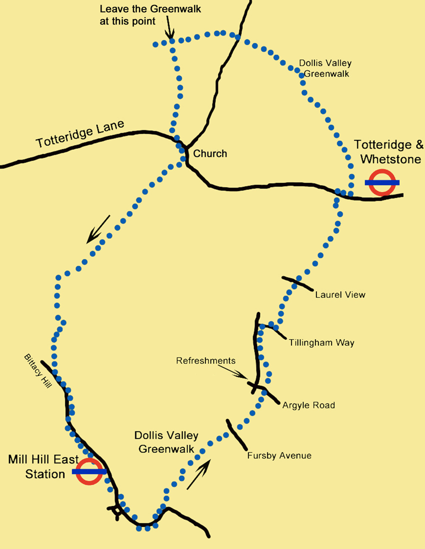
3. Pass a children’s play area and come to Argyle Road. At this point there is the opportunity for refreshments by turning left for 100m to reach a junction where there are a number of shops, including a café and a patisserie. Otherwise, cross Argyle Road and continue along the Greenwalk. After 250m the path joins a road (Southover), on which you turn right. 300m later, turn right again into Tillingham Way. After another 150m go through a gate on the left, signposted Moat Mount. Continue on the path. Cross over another road (Laurel View) and continue ahead. The path crosses a bridge and the brook is now on your left.
4. Continue ahead until you reach Totteridge Lane, a busy main road. You have now walked 5 km. Cross the road at the pedestrian crossing and turn right along the opposite footpath, past some shops. You reach a signpost which indicates the continuation of the Greenwalk to the left. At this point you can shorten the walk by going straight ahead in order to reach Totteridge & Whetstone Station. To continue the main walk, turn left and follow the Greenwalk through a broad section of parkland, with the brook on your left. After 1.5 km you reach a fork near Western Way. Go left here and enter some playing fields, staying close to the brook. After 400m go ahead through a gap in a hedge and pass a brick building to reach a road (Barnet Lane).
5. Cross the road, going slightly to the right, and continue along the path, which starts to rise after 400m. After another 200m it descends again to reach a sunken path which crosses the Greenwalk. At this point leave the Greenwalk to take the path to the left over a bridge. You come to another junction of paths, where you go straight on between hedges. After 500m cross the end of a residential cul-de-sac. Continue ahead on the path and cross another road, still following the same path, until you emerge on Totteridge Lane, where you turn left towards a junction with a war memorial.
6. Before reaching the junction, cross to the pavement on the right-hand side of the road. Continue until you are opposite St Andrew’s Church on your left. Then take a footpath on your right going downhill signposted Mill Hill 1.5 miles. At the bottom go ahead, with fields on your right and a wooden fence on your left. At the end of this long path, go through a gate into a large field. Cross the field, which may be muddy, maintaining your direction, towards a prominent building on the skyline.
7. At the far side, go through a gate and continue in the same direction on a footpath, with a fence on your right, to reach Burtonhole Lane. Turn left on this lane and walk uphill past Mill Hill Village Cricket Club. Continue on the lane as it swings left by the entrance to Mill Hill Country Club. At the next junction turn right steeply uphill for a short distance. Turn left into Eleanor Crescent but then immediately right through a gate onto a path leading into the woods. Follow this footpath and after 250m reach a main road (Bittacy Hill) on which you turn left. To reach Mill Hill East Underground Station, you have one kilometre of downhill walking ahead of you, with good views across London. Alternatively, you can catch a bus from here to the station.
Information on Things You Will See
Mill Hill East Stationwas opened in 1867 as part of the Great Northern Railway. It became part of the tube network in 1941 when Mill Hill East was home to the Middlesex Regiment. The 1941 reopening under war-time conditions, was to allow easy access to the barracks. Mill Hill East Station is served by a shuttle service from Finchley Central and is the terminus of the only single track branch on the Northern Line. It is also the least used station on the Northern Line with approximately 1.3 million passengers per year.
The Dollis Valley Greenwalk is a footpath in the London Borough of Barnet between Moat Mount Nature Reserve and Hampstead Heath. The walks connects a series of green spaces and wildlife corridors. It is 16Km (10miles) long and mainly follows the Dollis Brook. It was developed with the help of the Countryside Commission and in 2009 received a £400k grant from the Mayor of London as part of his “Help a London Park” scheme to improve cycle paths, lighting and general accessibility. Care has been taken to improve natural habitats such as wetland, woodland, reedbeds, hay meadows and landscaping. Information boards are provided to uncrease enjoyability and awareness.
- Details
- Hits: 10104
Walk 8 From Morden, at the southern end of the Northern Line, to Waddon Ponds via the Wandle Trail
|
Distance |
10.5 km (6.5 miles) |
|
Underfoot |
Mostly paved surfaces |
|
Outward Journey |
By Norther Line to Morden- about 30 minutes from Central London |
|
Return |
By train from Waddon |
|
Points of Interest |
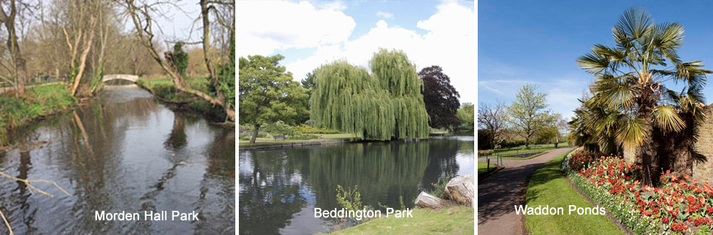
Morden Hall Park, River Wandle, Beddington Park |
|
Refreshments |
Stable Block Cafe in Morden Hall Park |
|
Public Toilets |
In Morden Hall Park |
|
Shortening the Walk |
Buses from several rpoints along the route |
What To Expect From This Walk
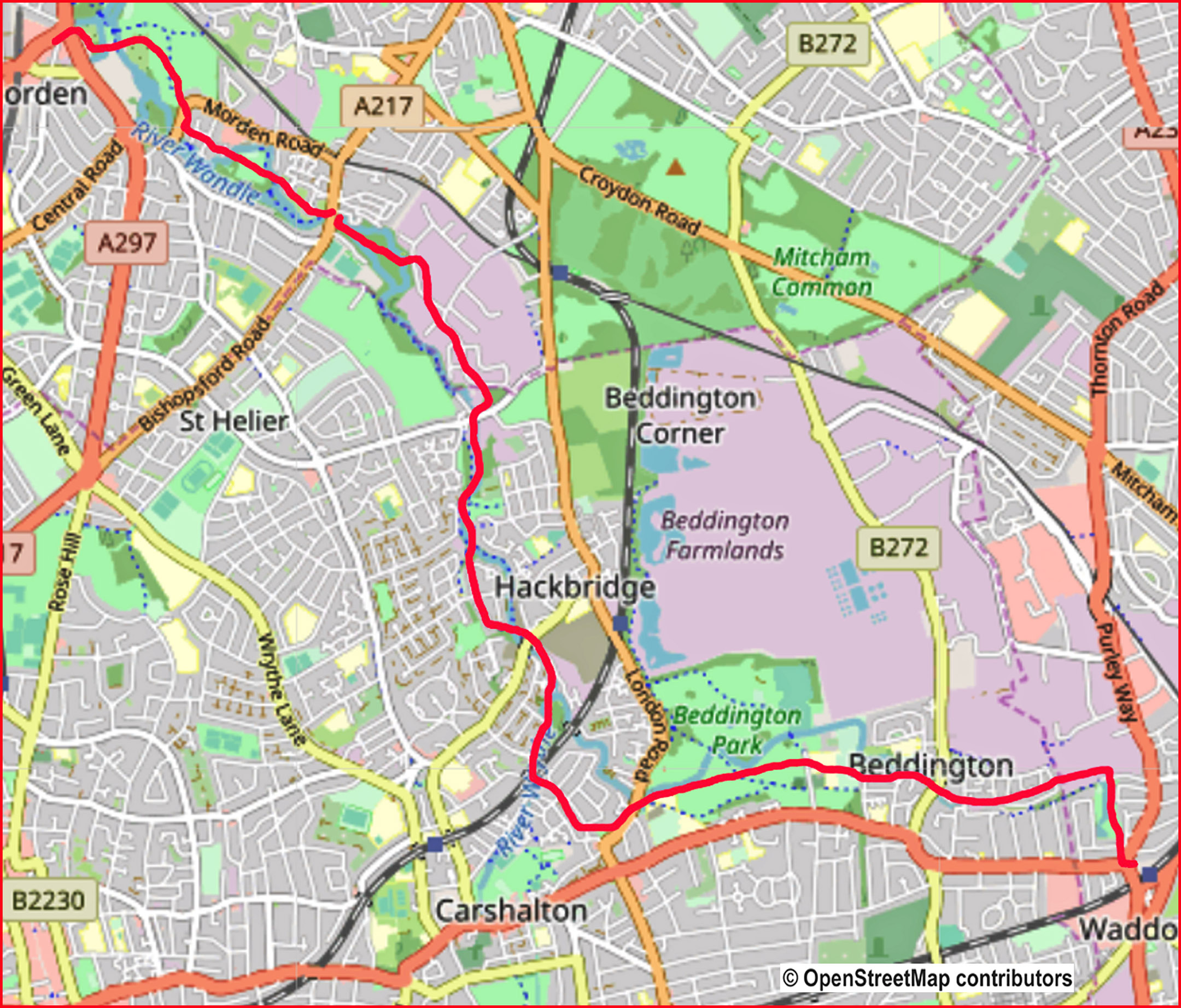
This is an easy walk following a ribbon of green parkland along the River Wandle through South London. The Wandle rises in the North Downs but is hidden underground until it emerges at Wandle Park in Croydon. From there, it is 14 km (9 miles) long and runs through London to join the Thames at Wandsworth. In its industrial heyday, it was one of Britain’s hardest working rivers, with over 90 mills along its banks. Today, the trail allows local people to enjoy the flora and fauna of this typical chalk stream in the heart of South London. This walk follows the river south-west towards Croydon from Morden. The Wandle Trail Partnership has published a brochure of the trail.which you can download from www.sustrans.org.uk.
Route Directions
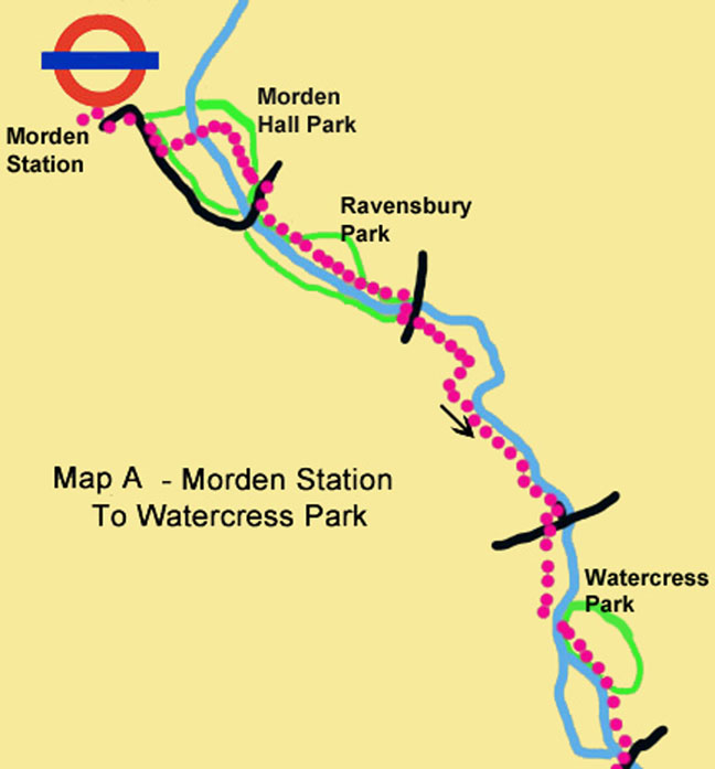
1. Turn left from the station onto London Road (the A24). Cross to the other side and walk to the roundabout at the junction with Morden Hall Road. Turn right and cross at the lights. Continue for 200m to reach Morden Hall Park entrance. On entering the park, keep ahead, with a waterwheel to your right and the stable block to your left. Cross a bridge and walk to a junction of paths, where you turn right onto a broad path. 150m further on, ignore a left turn signposted to Phipps Bridge and continue straight on, following the signs for Hackbridge and Carshalton. At the point where the path leaves the park, turn right onto Morden Road.
2. Cross over and after 200m turn left at a signpost into Ravensbury Park. Cross over an unusual-looking bridge and walk through the park, keeping the river on your right. Leave the park by crossing one last bridge and swinging right to reach Bishopsford Road. Cross at the pedestrian crossing and continue ahead along a track to the right of the park gates, with a ditch and a stadium on your right and a metal fence on your
3. In 300m the path becomes fenced in on both sides. Where the fence on the right ends, turn right to rejoin the riverside path, with the river now on your left. Continue to Watermead Lane, which leads out to a larger road. Go right for a few metres to cross at the lights to an information board, which shows the onward route. Go ahead on the footpath, then turn left onto a track signposted Buckhurst Avenue. The river disappears temporarily here. When you meet it again, cross a bridge on the left and follow the path through Watercress Park

4. Follow the path as it swings right at a junction and later rejoins the river bank. Cross a small road and keep the river on your right until you reach Hackbridge Road. Go right across a bridge and then turn left to continue walking along the Wandle Trail, with the river now on your left. Come out on a road (River Gardens, which becomes Mill Lane). Follow it under a railway bridge. Turn left into Butter Hill (signposted as a Wandle Trail shortcut) and continue for 750m until you meet London Road (the A237). Turn left, cross the road and continue to Derek Avenue, where you take a path going diagonally right which leads into Beddington Park.
5. Walk along the left bank of the lake until the path turns right over a stone bridge. Leave the path at this point and go straight ahead across the grass. After passing some trees, turn right to meet the river again. Stay on the left bank and ignore a red sandstone bridge but cross over at the next (white) bridge and turn left past houses to a small car park. Go diagonally right across a field, turning left at a wall. At a fork take the right-hand path to regain the river bank. Leave the park and follow a series of signs to Waddon Ponds and Bridleway to Mill Lane for about 1.5 km. Take care not to miss the sign for a right turn into Bridle Path, a residential street. The river is often hidden from view on this section of the walk.
6. When you reach Waddon Ponds, turn right down the far side of the ponds. Leave the park and turn right to the junction with the A23. Cross at the lights and pass a McDonald’s on your left to reach Waddon Station. You also have the option of taking the Croydon tramlink from Wandle Park.
Information On The Things You Will See
Morden Hall Park is a National Trust property with 125 acres of parkland with the River Wandle meandering through it spanned by numerous foot bridges. The estate contains Morden Hall, Morden Cottage, an old Snuff Mill, and many old farm buildings, some of which are now a garden centre and a city farm. The rose garden has over 2000 roses.
Ravensbury Park The park was part of the medieval Ravensbury Manor, which dated back to the thirteenth century. In the seventeenth and eighteenth centuries the site was the location of a calico mill and pleasure gardens. In 1929 the local authorities purchased the site and opened Ravensbury Park in May 1930. Some of the trees date back two hundred years.
Beddington Park was the former manor house of the Carew family lost to money lenders and bad debts in the 1950s. The park is one of the most rich, historical and archaeological sites in south west London with evidence of settlements dating back to the late Bronze Age. The discovery of a Roman Stone Coffin in 1930 lends weight to the idea that a grand Roman villa and bath-house once stood to the north side of the park