- Details
- Hits: 15475
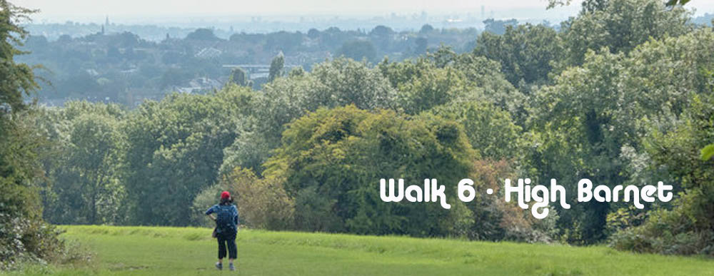
Walk No 6 - From High Barnet, at the northern end of the Northern Line, to Arnos Grove with a shorter option to Cockfosters.
|
Distance |
Full walk to Arnos Grove - 10.5 km (7 miles) Shorter Option to Cockfosters - 6.5 Km (4 miles) |
|
Underfoot |
Mostly paved surfaces but some woodland paths |
|
Outward Journey |
By Norther Line to High Barnet - about 30 minutes from Central London |
|
Return |
By Piccadilly Line from Cocfosters or Arnos Grove |
|
Points of Interest |
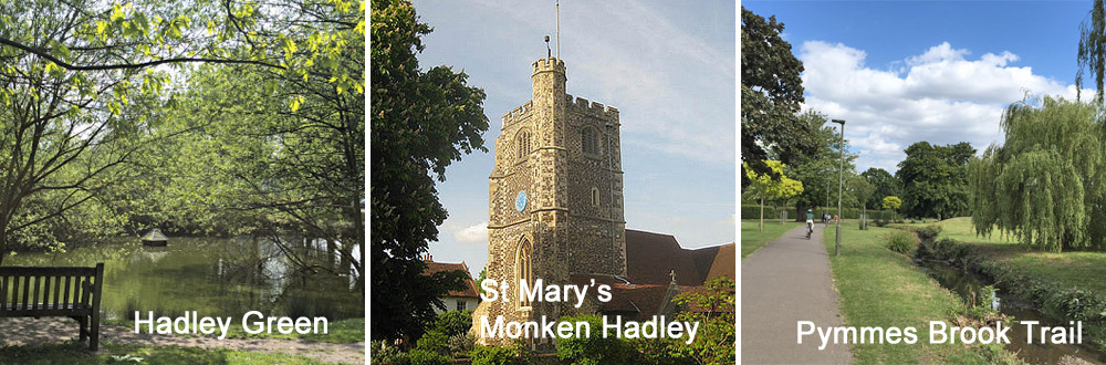
Hadley Green, Monken Hadley Common, Pymmes Brook |
|
Refreshments |
Cock Inn at Cockfosters |
|
Public Toilets |
At High Barnet Station |
|
Shortening the Walk |
Shorter option to Cockfosters as described |
What to Expect from This Walk
This walk starts at High Barnet Underground Station and ascends King George's Field with wonderful views over London. The route explores Hadley Green and Monken Hadley Common before crossing the main East Coast railway line between London and Scotland. You then descend to a junction with the Pymmes Brook Trail, where you have a choice between the full route to Arnos Grove Station or the shorter route to Cockfosters Station, both on the Piccadilly Line. Whichever you choose, you may wish to visit The Cock Inn (500m further on from the junction). If you choose the longer walk along the Pymmes Brook, there is 1.5 km of street walking before you regain the ribbon of parkland beside the brook.
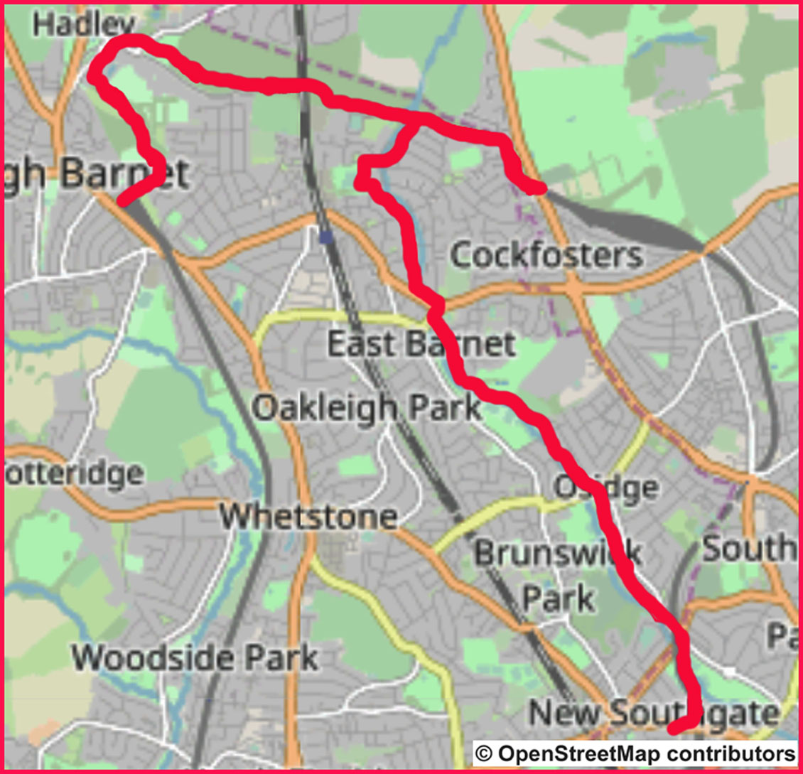
1. Leave High Barnet Station by going up the pedestrian ramp and turning right into Meadway. Walk downhill for 650m and turn left into Burnside Close. At its end, follow a path to reach a London Loop sign, which you follow by turning left through a gate. Go ahead slightly uphill. After about 100m follow the path as it turns left and then descends to a sometimes muddy junction. Turn right and ascend King George’s Field. As you climb, be sure to stop to look behind you at the expanding views over London. At the top there is an information board.
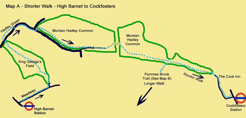
2. Cross Hadley Green Road and turn right to follow the perimeter of the Green. At its end, cross back over the road and follow the right-hand footway. The road swings right, with the church of St Mary the Virgin on your left. Shortly afterwards, you reach Monken Hadley Common. Cross over to the left-hand side of the road to continue in the same direction along the grass, staying close to the road. Enter the woods and follow a path which runs inside the woods parallel to the road.
3. After 500m you become aware that the noise of traffic has disappeared because the road has turned away from the woods. Emerge on a quiet drive which descends to a small car park. Go through the car park, swing left and then right to cross a bridge over the East Coast railway line. Continue ahead and descend through woods for about 400m to reach a signpost indicating that the Pymmes Brook Trail goes off to the right.
For the short walk (Map A) continue straight ahead at the signpost to reach the end of the woods. On leaving the woods, continue on a minor road to Cockfosters Station. Shortly after leaving the woods, you will pass The Cock Inn on your right.
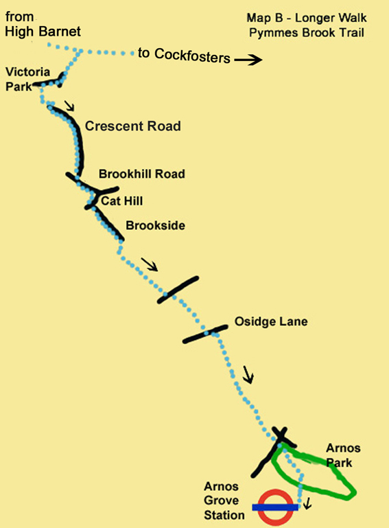
4. For the full walk (Map B) turn right at the signpost to join the Pymmes Brook Trail. Walk downhill beside the brook and immediately go under a bridge. Follow the path to reach a quiet suburban road. After 120m, turn right into Lawton Road. Follow the left-hand footway uphill beside a hedge. Take the second gap in the hedge to enter a small park and follow the path as it curves right and then left beside some tennis courts. At the end of the tennis courts turn left. You leave the park, still following the signs for the Pymmes Brook Trail.
5. Turn right and then left into Crescent Road, which you follow for about 700m. Turn left into Brookhill Road and right into Cat Hill. Descend Cat Hill and turn left into Brookside. Walk along the right-hand footway, with the Pymmes Brook in sight downhill across the grassy area to your right. Continue ahead for about 400m, after which you follow a path down to the brook. Turn left to walk alongside it.
6. After about 500m cross a road and continue walking over the grass on the left-hand bank of Pymmes Brook. After 300m cross another road and reach Osidge Lane. Cross over, turn left and then right to continue along a good path. After 1 km you emerge on another road beneath a railway viaduct. Cross under the viaduct and walk ahead into Arnos Park. Continue for 400m, passing two bridges over the brook. Take the third bridge to exit the park. Walk up Arnos Road to the main road and turn right to Arnos Grove Station. The Arnos Arms can be found at the top of Arnos Roa
Information on Things You Will See
King George's Fields is one of many identically named recreational areas all over the country, established as memorials to King George V who died in 1936. The site consists of a patchwork of fields, intersected by overgrown hedgerows, narrow strips of woodland and small streams. There are a number of magnificent old oaks, and breeding birds. The hill rises to approximately 130 metres and provides goods views southwards towards Hampstead Heath and Central London.
Monken Hadley Common is an area of fields and woodland, about 72 hectares in size, shaped like a wedge with its broad end half a mile wide at Monken Hadley and tapering to a point at Cockfosters. It is bisected by the main East Coast Railway Line. It was created as a common by an Act of Parliament in 1777. It is a site of importance for nature conservation and if you are very lucky you may see a muntjac deer which use the common for grazing.
Pymmes Brook Trail runs for 10 miles across north west London from Monken Hadley Common to the Lee Valley Leisure Complex at Edmonton. It is named after William Pymme a 14thC landowner. Jack’s Lake or Beech Hill Lake was formed by damming the brook. The brook uses a series of parks and pathways to create a recreational route.


- Details
- Hits: 9172
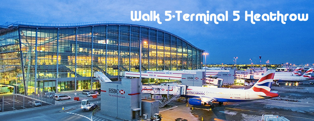
Walk 5 - From Terminal 5 Heathrow at the Western End of the Piccadilly Line to Staines
|
Distance |
9.5 km (6 miles) |
|
Underfoot |
A mixture of roads and footpaths. May be muddy after wet weather. |
|
Outward Journey |
By Piccadilly Line to Heathrow Terminal 5 - about 50 minutes from Central London |
|
Return |
By train from Staines |
|
Points of Interest |
Terminal 5. Colne Valley Park, Staines Moor |
|
Refreshments |
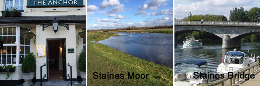
Cafés in Terminal 5, The Anchor pub in Horton Road, pubs and cafés in Staines |
|
Public Toilets |
At Terminal 5 and Staines Railway Station |
|
Shortening the Walk |
No opportunities |
What To Expect From This Walk
When I started to plan these routes, I did not think I would find a walk from the end of the Piccadilly Line at Heathrow. However, with the help of a friend, I discovered this interesting route from Terminal 5. The first part of the walk follows a section of airport perimeter road and then leaves the airport to access the Colne River Valley. You follow a mixture of riverside paths and roads through the village of Horton before reaching Staines Moor, an attractive open area of heath. From here it is only a short walk to Staines and the River Thames. On the early part of the walk you will be accompanied by the sight of large aircraft flying a few hundred metres above your head.
Route Directions
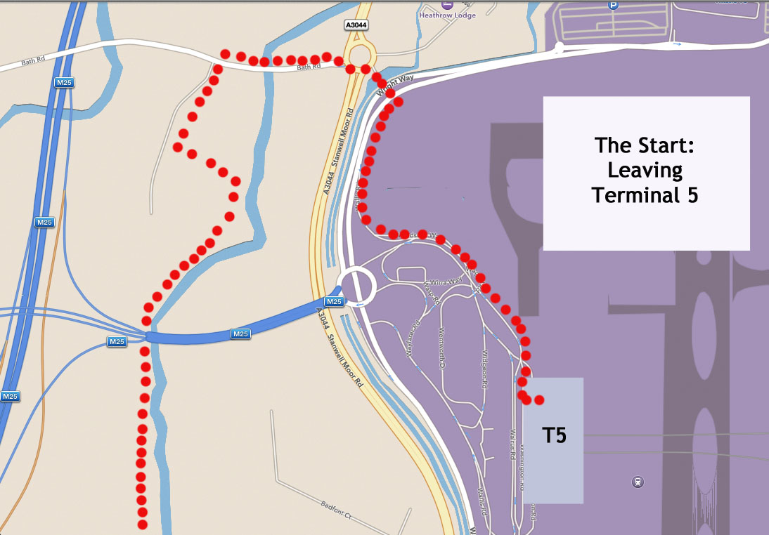
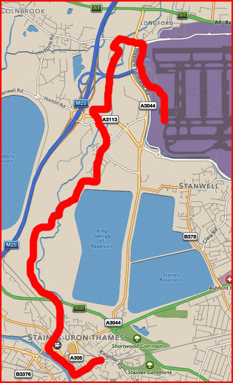
1. The walk starts at Heathrow Airport in the Arrivals Hall of Terminal 5. Stand with your back to the International Arrivals Gate, facing the coffee shop in the centre of the Arrivals Hall (operated at the time of writing by Costa Coffee). Turn right and walk towards the far end of the hall. After 100m you pass the glass covered lifts on your left. Turn left here under a suspended yellow sign saying Exit, Buses, Car Rental, Taxis and leave the terminal building to enter a covered area used by buses and cars. Walk ahead using the clearly marked pedestrian crossings to cross a series of vehicle lanes. Continue in the same direction to leave the covered area between parked cars.
2. Do not cross the road ahead of you (Widgeon Road). Instead, turn right and walk along the side of the road, making your way past flowerbeds and motorcycle parking bays. The Arora Building is on the opposite side of the road on your left. Ahead you can see a concrete overpass which carries vehicles to the first-floor Departures level of Terminal 5. Go under this and continue ahead to reach the airport perimeter road. Take great care along this section, which is a one-way traffic system with a number of intersecting roads without footways. Once you reach the perimeter road (where Wallis Road comes in from the right) you regain a footway.
3. Turn left onto the perimeter road, with its fence on your right, and walk away from Terminal 5, using the wide right-hand pavement. After 400m turn left at a set of traffic lights to cross to the other side of the perimeter road. Leave the airport by crossing a bridge which provides vehicle access to the perimeter road, to arrive at a round-about. Go to the left to cross the A3044 (Stanwell Moor Road). Your aim is to reach the Bath Road on the opposite side of the roundabout (signposted Colnbrook and Pyle).
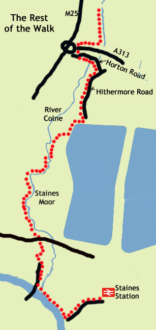
4. Walk down Bath Road, crossing over the River Colne. Shortly after a bus stop on your left, turn left through a gate into the Colne River Valley. Follow a track which goes ahead for 300m, then turns left and later right near the river. Pass beneath a major road and go left through a gate to continue alongside the river on a track through a field. After 400m the track turns right, parallel to the busy road which you can see and hear ahead. When you reach the next corner of the field, turn left on a bridleway. Go through a tunnel under the road and turn left on an area of tarmac to reach Horton Road, where you turn left again. Follow Horton Road for 800m until you see The Anchor pub ahead of you at a T-junction.
5. Turn right at the T-junction into Hithermore Road, which soon turns left. After 250m ignore a metal gate and track to the right, which has a sign for a private fishing area. Instead, continue along Hithermore Road to its end and follow the tarmac footpath which goes towards a reservoir embankment. The path turns right along the metal boundary fence. Follow the path along the fence, keeping a lookout for a metal kissing gate on your right. Go through the gate and walk through a lightly wooded area. A boardwalk leads to a footbridge and onto an extensive area of open land with an information board. This is Staines Moor and the River Colne is on your right.
6. Continue for 250m and then cross the river on a stone footbridge with metal handrails. Go ahead over two wooden boardwalks and then turn left to follow a clear path along the right-hand bank of the river. Follow the river for 800m until you see another bridge. Do not cross over this bridge. Instead, go half-right towards an underpass in the embankment of the A30. Go through the underpass, then through a metal gate and follow a path straight ahead over a field to cross a small watercourse. After another 100m, the path swings left. You, however, should go through a kissing gate to continue ahead.
7. Cross the railway line and turn left along the bank of the River Colne, which you follow all the way to the end of the path in Staines. Turn left and then swing right to reach Staines Bridge over the Thames. To get to Staines Railway Station do not cross the bridge. Instead, descend to the riverbank using a set of steps to the left of the bridge parapet. You then walk along the river bank until a Thames Path sign directs you to turn up to the main road, where you continue in the same direction along the footway, passing under a railway bridge. Take the third road on the left (Gresham Road) to reach the station.
Information on Things You Will See
Terminal 5 is Heathrow’s most recent terminal and was officially opened by the Queen in March 2008. The first flight to arrive was BA026 from Hong Kong flown by Captain Lynn Barton, British Airways’ first woman pilot. Designed by British architect Richard Rogers, the main terminal building is almost 400m long and has a floor area of over 350,000 square metres. The period from conception to completion lasted almost 20 years due in part to the longest ever public enquiry in the UK. At the time of writing, a proposal for the construction of a third runway at Heathrow has been backed by Parliament. If fully implemented, the expansion will affect the Colne Valley Trail and there is a danger that this walk may disappear.
Colne Valley Park covers over 100 square kilometres and consists of a mosaic of farmland, woodland and water, offering a real taste of countryside to the west of London. The park is managed by a Community Interest Company which is determinedly opposed to Heathrow’s expansion proposals, as these would have a far-reaching impact on the valley’s biodiversity, through loss of habitat and habitat connectivity.
Staines Moor is an area of common land lying within the Colne Valley that has been designated as a Site of Special Scientific Interest for its diverse range of flora and fauna. 130 species of bird have been recorded on the moor, which was described by Bill Bryson as “an astonishing sight – a sweep of green and golden countryside … an unexpectedly lovely walk”.
- Details
- Hits: 11467
Walk No 4 - A Circular Walk from Uxbridge at the Western End of the Piccadilly and Metropolitan Lines
|
Distance |
10 km (6 miles) |
|
Underfoot |
Mostly paved surfaces. Some riverside paths |
|
Outward Journey |
Piccadilly or Metropolitan Line to Uxbridge (about 40 - 50 minutes from Central London) |
|
Return |
By outward route |
|
Points of Interest |
Grand Union Canal, Little Britain Lake, River Colne |
|
Refreshments |
Cafes and pubs in Uxbridge. Also can-side pubs |
|
Public Toilets |
At Uxbridge Station |
|
Shortening the Walk |
No options |
What to Expect From This Walk
This is a lovely walk beside attractive waterways. Once clear of the town centre, you will be walking entirely beside canals and rivers, either along towpaths or through riverside woods. In January and February look out for snowdrops near the river bank. You will see longboats, ducks, geese and swans and the occasional dog walker. Look out for cyclists on the canal section: many come up behind almost silently without the warning of a "ding" on their bell..You can avoid 1 km of road walking when leaving Uxbridge town centre by taking the no. 3 bus to Iver to the bridge over the Grand Union Canal, where the waterside section commences. Stop N is adjacent to the station and the bus runs every 20 minutes on weekdays, but less frequently at weekends.Uxbridge is a terminus for both the Piccadilly Line and the Metropolitan Line. Arriving by the latter is quicker. To shorten the journey even more, you can take the Jubilee Line out of Central London and change to the Metropolitan Line at Finchley Road.
Route Directions
1. Leave the station and cross the street ahead of you. Enter Windsor Street and walk down to a large roundabout. Cross at the pedestrian lights and pass to the left of a building (Capital Court). Use the next two sets of lights to reach the opposite side of the roundabout. Turn right along the footpath and then left into New Windsor Street, which is signposted A4007 Uxbridge Industrial Estate. After 100m you arrive at a humpback bridge over Fray’s River. Cross to the right-hand footway at the pedestrian crossing. After another 400m you reach a bridge over the Grand Union Canal.
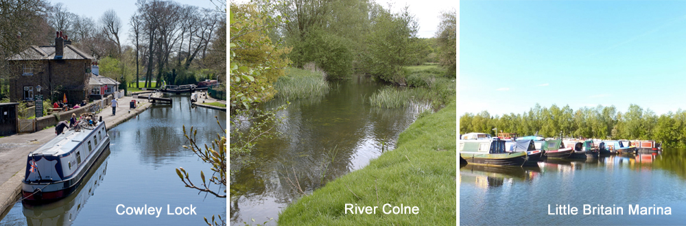
2. Cross the bridge and turn right to descend to the towpath. Turn right again and follow the towpath back under the bridge. Continue south along the tow-path. After 1.4 km, follow the towpath as it crosses to the opposite bank using a road bridge. Almost immediately, you reach Cowley Lock. Continue along the left-hand side of the canal for another 1.5 km. After going under a road bridge you will see the Packet Boat Marina on your right. Shortly afterwards, you come to a footbridge with a sign for the Slough Arm of the canal. This is the Cowley Peachey Junction. Turn right over the bridge to go ahead (west) alongside this new stretch of waterway.
3. After 750m you come to a metal footbridge signposted London Loop and Hillingdon Trail. Go up the path on the left and then turn right across the bridge to leave the Slough Arm. From the bridge you can see (and hear) the M25 in the distance. You are now walking north, back towards Uxbridge. The path winds among trees and after 300m reaches Little Britain Lake. 30m further on, cross a footbridge on your left. Turn right, still following the London Loop. You are now walking along the left bank of the River Colne. This is a delightful stretch of river bank through woodland. When you reach a road, turn right and cross to the other side of the river.
4. Turn left, still following the London Loop, with the river now on your left and a high metal fence on your right. Continue for another 1.5 km until the path turns away from the river. It passes between some houses and then becomes a road. At a crossing road, go straight ahead into Culvert Lane and follow it until it reaches the Grand Union Canal. You are now back on your outward route. Turn left to reach the A4007, where there are two pubs, The General Eliott on the left and The Dolphin on the other side of the bridge. Cross the bridge and follow the outward route back to Uxbridge Station.
Information on the Things You Will See
Uxbridge began as settlement on the River Colne. Until the 19th century the prosperity of the town depended on its corn market and its importance as a flour milling centre, with thirteen mills along the Colne and Fray’s rivers. The 20th century saw rapid change, due to the extension of the Metropolitan Railway to Uxbridge in 1904. In 1918 the Royal Flying Corps moved into Hillingdon House, from where the Battle of Britain was directed.
The Grand Union Canal is the longest canal in the UK and runs for 220 km (137 miles) from London to Birmingham. It is the result of the amalgamation of several independent waterways, from 1894 to 1929. It is a broad canal, so called because its locks are wide enough to accommodate two narrowboats side by side or one wide-beam barge.
The River Colne rises in Hertfordshire and flows south to join the Thames at Staines. The section in this walk forms the boundary between Buckinghamshire and Greater London. Digging for gravel and clay along its lower course south of Rickmansworth has created a long chain of pits which have flooded to become lakes. These are habitats for wildlife and are protected as nature reserves.
- Details
- Hits: 14227
Walk 3 - A Circular Walk from Cockfosters, at the Northern End of the Piccadilly Line, in Trent Country Park
|
Distance |
6.5 km (4 miles) |
|
Underfoot |
Woodland paths and paved surfaces |
|
Outward Journey |
Piccadilly Line to Cockfoster (about 50 minutes from Central London) |
|
Return Journey |
By outward route |
|
Refreshments |
Café in Trent Park, The Cock Inn |
|
Public Toilets |
At Cockfosters Station and near the café in Trent Park |
|
Points of Interest |
Sassoon Obelisk, Water Gardens, Trent Park House |
|
Shortening the Walk |
Omit the detour to the Water Gardens |
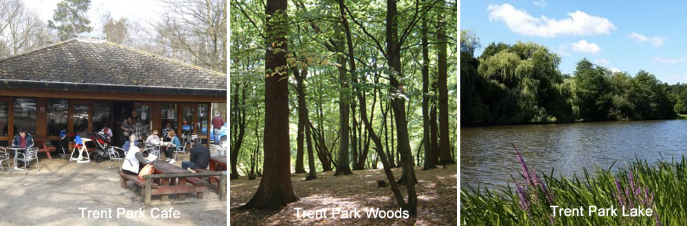
What To Expect From This Walk This is an easy but pleasant walk through woodlands and meadows in Trent Country Park, a remnant of the ancient royal hunting ground of Enfield Chase. You can examine the Sassoon Obelisk, explore the Water Garden and catch glimpses of Trent House. The hubbub of London life seems a million miles away. After the walk you can visit The Cock Inn, not far from the gates of Trent Park
Route Directions
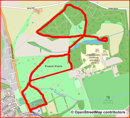
1. Leave Cockfosters Station by climbing the steps to the road. Turn right and right again to enter the access road to the car park. Go through a gate which is set in the railings on your left, signposted for the London Loop. Continue between fences for about 200m, then turn left at the end. Go through a gap in a hedge and across the top of a small field to enter woodland. Continue to follow the London Loop signs to reach a grassy open space, which you cross to reach the main drive to Trent Country Park.
2. Turn right here towards the public toilets, the café and the children’s playground. Pass to the right of the café. Turn left and then right into the woods, guided by more
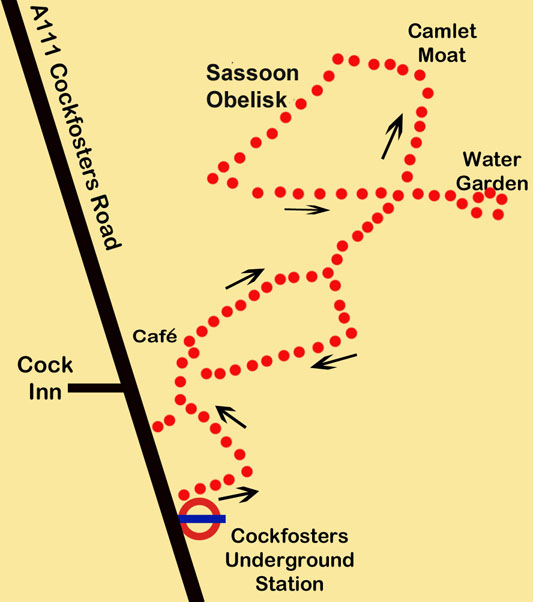
London Loop signs. Follow the path for about 250m as it descends through the trees. Where the trees end, continue along the left edge of a field to reach a junction of paths. Turn left here on a broad path which curves right through a large meadow, with a lake on your right and rising ground on your left.
3. At the end of the path, reach a multi-armed signpost. Turn left uphill towards Camlet Moat, with the meadow on your left. Enter woods, still on the London Loop, and follow the path as it swings left to continue through the trees. After 400m, you will see the end of the woods ahead of you. Do not follow the London Loop, which turns right here to leave the park. Instead, you turn left and continue within the boundary fence of Trent Country Park. In 100m, you reach the Sassoon Obelisk. Pass to the left of the obelisk and walk to the corner of the woods. Turn left downhill, still within the woods. You now come to the meadow again from the opposite side. Descend diagonally across the grass to arrive back at the multi-armed signpost.
4. To make a short detour to the Water Garden, follow the direction indicated on the signpost. This sunken patchwork of paths and pools was originally laid out by Sir Philip Sassoon in the late 1920s. Trent Park House can be seen beyond the lake on your right. Retrace your steps to return to the signpost.
5. From the signpost, walk back along your outward route with the lake now on your left. At the next junction of paths, go straight ahead uphill on a rough track, which takes you up to a paved drive. Turn right along the drive and follow it until you pass the café on your right. From here, follow the drive out to Cockfosters Road (the A111) and turn left at the entrance gates to return to Cockfosters Underground Station. However, if you wish to visit The Cock Inn, turn right at the gates, cross the road and take the first left into Chalk Lane.
Information on Things You Will See -
Cockfosters, according to the Oxford Dictionary of English Place Names, refers to the “house of the chief forester” and the name was first mentioned in 1524.
Trent Country Park was originally part of Enfield Wood, later known as Enfield Chase, where local villagers put their cattle out to pasture and went foraging. For over 350 years Enfield Chase also served as a royal hunting forest, enjoyed by Henry VIII, Elizabeth I, James I and Charles I. Nowadays, the park covers 413 acres and forms part of London’s Green Belt. It is open every day of the year from 8.00 a.m.
Muntjac deer inhabit the park. They are a small, stocky breed, russet brown in colour in summer and grey/brown in winter. The Bucks have short (10 cm) antlers. They were introduced to Britain from China in the early 20th century. Through escape and deliberate release, they are now widespread and increasing in number and range.
Trent Park House was originally built in the 18th century, but it has undergone many changes since then. In the early 20th century, the house was bought by the Sassoon family. During the Second World War, it played a critical role in the ‘secret war’ against Nazi Germany when it housed captured German officers. They were allowed to live in relative luxury, little realising their secretly recorded conversations were providing invaluable information to MI9, the British intelligence agency. After the war, the Trent Park estate became part of London’s Green Belt and in 1973 the Greater London Council officially opened Trent Country Park to the public. Trent House became a teacher training college in 1950, and later formed part of the Middlesex University campus. In 2012 the university vacated the site and it was acquired for development as a private housing estate. As a feature of the redevelopment, proposals have been agreed for a museum.