- Details
- Hits: 4552
Walk 26 -
From Edgware Tube Station, at the Northern End of the Northern to Mill Hill East via Mill Hill Park and Arrandene Open Space

Walk Distance 6.5 Kilometres (4 miles)
Underfoot Mostly surfaced paths. Some footpaths in Arrandene Open Space
Journey Time (from Central London to Stratford) 30 minutes
Getting Back to Central London By tube from Mill Hill East (change at Finchley Central)
Points of Interest Nature Reserve (Sat/Sun), Mill Hill Park, Arrandene Open Space
Refreshments - Cafes at Edgware, Shops and Takeaway Fish & Chip Shop in Pursley Road
Opportunities For Shortening This Walk None
Route Description
 1. Turn right out of Edgware Tube Station into Station Road. After 60m, turn right into Bakery Path and follow it through to Brook Avenue. Turn right, and walk to the end of the road. Go into a small park via a metal kissing gate and go across a bridge over Deans Brook. Follow the path to reach the corner of Farm Road and West Way. Go ahead up West Way to the end of the road. Turn right into Deans Lane. Walk to the pedestrian lights, cross the road to the opposite footway and continue in the same direction.
2 Saturday and Sunday if the nature reserve is open – take the path which descends immediately from the road on your left and enter a nature reserve via a metal gate. Follow the path and then go right to exit in The Meads. Re-join the instructions as at (3) below.
3. Monday to Friday, or if the nature reserve is closed - Go ahead and turn left into Dryfield Road. After 450m pass a green on your right and swing left to enter The Meads which runs parallel to Burnt Oak Brook. Follow this road to the very end and go through a green gate in the left hand corner by the houses, to enter Lyndhurst Park. Follow the path straight through the park and up some steps into Bunns Lane.
4. Go right on Bunns Lane and use the first traffic island to cross to the other side. Walk, in the same direction, past a roundabout and continue along the left hand footway. Follow Bunns Lane as it swings left to pass under a railway line and a the M1 Motorway. Reach Flower Lane with Mill Hill Park ahead of you: cross over and turn left up the footway. At this point you can walk diagonally left across the grass of the park or walk up the footway until you reach a path on your right. Follow the path and go under a subway into another section of Mill Hill Park.
5. Continue straight ahead to pass some tennis courts on your left. Before reaching a car park, turn right along a smaller path and follow it until you exit the park through a kissing gate into Wise Lane. Turn right for 20m, cross the road and go through another gate, set in the hedge, into Arrandene Open Space. Go ahead uphill on a grassy path. At the top, ignore a crossing path and go to the right around some trees to enter a woodland track in the bottom right hand corner of the open space. This leads you uphill to another grassy area. Take the broad grassy path, going slightly right, which descends. Go through a gap in a row of trees and continue ahead passing through some more light woodland. Finally turn right to reach the exit to Wise Lane.
6. Turn left, cross the road and go right along Milespit Hill. Walk to the end and turn left into Pursley Road. After 50m there are shops on the left. Go ahead over a bridge. At the far side of the bridge, cross the road and go down some steps beside the parapet of the bridge. At the bottom, swing right on to what appears to be a disused railway line. Pass under the bridge a walk for 400m to pass through a metal field gate into a grassy area with houses ahead. Enter an alleyway between the houses and continue ahead until you reach a minor road (Bettacy Road). Turn right and follow the road as it swings left to reach a main road (Bettacy Hill). Turn right into Mill Hill East Station.
- Details
- Hits: 4604
Walk 25 - From Brixton Tube Station, at the Southern End of the Victoria Line to Herne Hill via Brixton Windmill and Brockwell Park
Walk Distance 5 Kilometres (3.5 miles)
Underfoot Paved throughout
Journey Time (from Central London to Brixton) 10 minutes
Getting Back to Central London Return by train from Herne Hill to Victoria
Points of Interest Brixton Windmill, Brockwell Park
Refreshments - Cafes and pubs in Brixton, cafe in Brockwell Park
Opportunities For Shortening This Walk - Bus stops en route for return to Brixton
Route Description

1. Come out of Brixton Station and turn left to reach a busy road junction. Go ahead and cross the A2217 Coldharbour Lane to reach a area of concrete and trees known as Windrush Square. Turn right immediately and cross Effra Road to reach the triangle of land formed by the junction of Effra Road and the A23 Brixton Hill. You are going to walk up the right hand side (Brixton Hill) of this triangle which contains St Matthew’s Church. Turn left and walk past the right hand side of the church and proceed up Brixton Hill keeping to the left hand footway. Pass Brixton Orchard and enter Rush Common, a green area parallel to the road which will separate you for a few hundred metres from the busy traffic.
2. Where the green area finishes, cross Water Lane and rejoin the footway of Brixton Hill. Use the next set of pedestrian lights to cross to the other side of Brixton Hill. Turn left up the footway and right into Blenheim Gardens. Walk to the end of this short road and enter Windmill Gardens to see Brixton Windmill. After viewing the windmill, retrace your steps to Brixton Hill. Cross over, turn right and walk up the left hand footway to Elm Park which is the fourth road on the left. Turn left into Elm Park and walk down this quiet street for 400 metres. Turn left into Claverdale Road to reach the A204 Tulse Hill. Cross with care and enter the pathway between houses to the right of the petrol station.
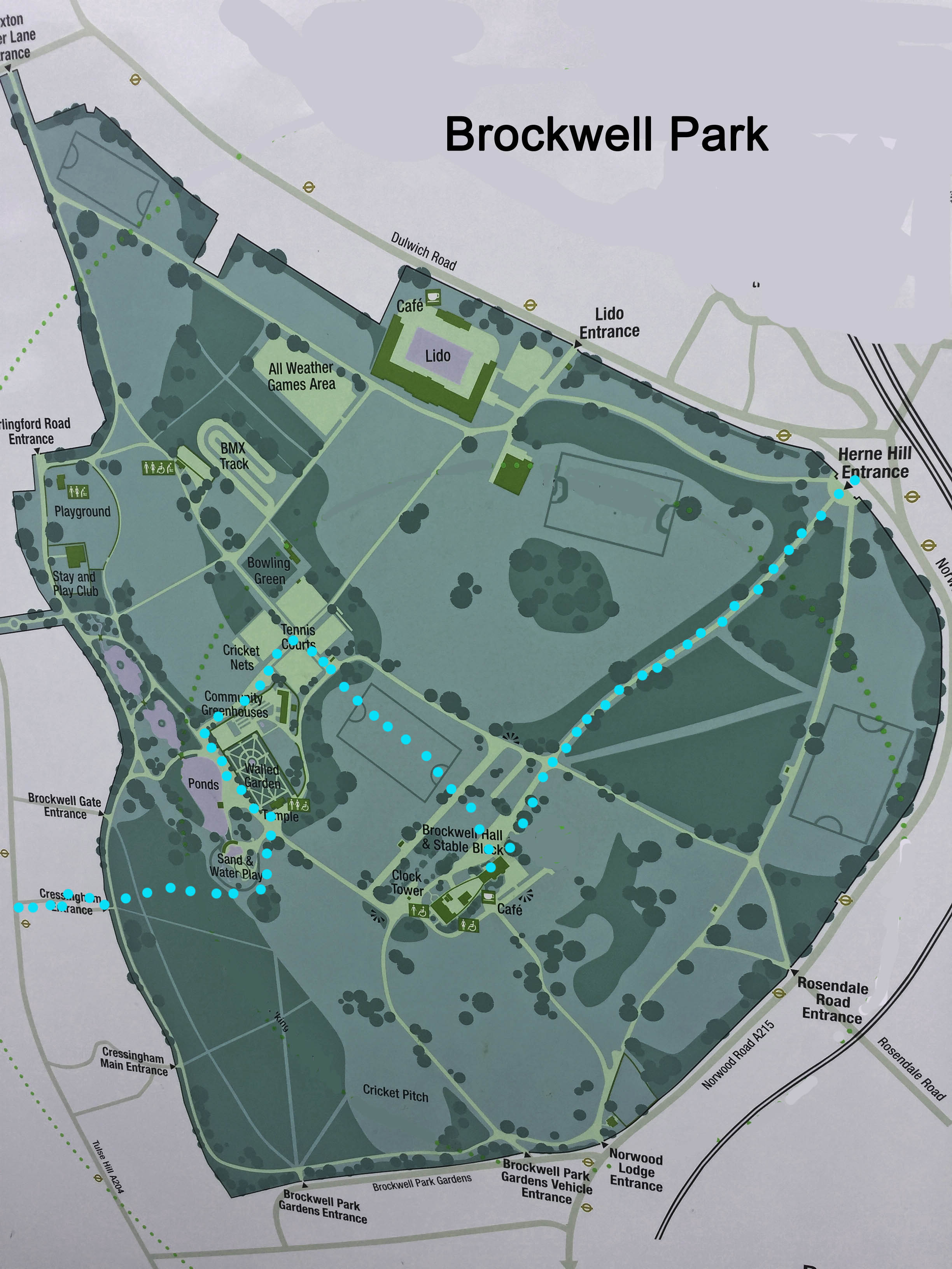
3. The pathway turns left, right, left and right again to reach Brockwell Park. You can follow almost any route through the park without getting lost. (See the plan on this page.) So, what follows, is simply a suggested route. Go ahead across a grassy path and turn left around a hedge. Visit the walled garden ahead on your right and then walk past the pond on your left. Swing right around the Community Greenhouses, pass between tennis courts and turn right again to reach a grass area. Walk across the grass to visit the park café which offers a good range of food and drink.
4. Upon leaving the café head downhill for the Herne Hill exit of the park and either catch a bus back to Brixton or a train to London from Herne Hill Station which can be found in Railton road.

- Details
- Hits: 4547
Walk 24 - From Walthamstow Central, at the Northern End of the Victoria Line to Tottenham Hale via Walthamstow Wetlands
Walk Distance 9.5 Kilometres (6 miles)
Underfoot Paved or solid pathways, no mud
Journey Time (from Central London to Walthamstow) 25 minutes
Getting Back to Central London Return by Victoria line or train from Tottenham Hale
Points of Interest Walthamstow High Street, Walthamstow Wetlands, River Lee
Refreshments - Cafes and pubs in Walthamstow, visitor center cafe, pub nearby.
Opportunities For Shortening This Walk - Go straight to Tottenham Hale Station from the visitor center
Route Description
1. When leaving Walthamstow Central Station, at the top of the escalator, turn left and follow the signs to “Selborne Road” up some steep steps. Emerge in Walthamstow Bus Garage. Turn left and cross the road to an open green area. Swing to the right and walk towards a street of shops which you can see ahead. This is the High Street which is pedestrianised. Turn left and pass many shops and stalls. You are going to walk approximately 3 Km in this direction.
2. Cross Willow Walk and continue ahead down the High Street. After 1.4Km cross St James Street and walk down Coppermill Lane with houses on both sides. Pass the Coppermill Inn. Approximately 2 Km from where you joined the High Street the road narrows and changes in nature. The view open out on both sides with a reservoir on the right and a Thames Water treatment center on the left. Continue ahead.
3. Walk for another 850m and, just after a slight bend in the road, turn right across a bridge to enter “Walthamstow Wetlands”. Follow the pathway as it passes Coppermill Tower. Continue for another 100m and, then, turn right over a concrete bridge. At the end of the bridge turn sharp left into an open space and look for a pathway going to the right. Go through a gateway and swing left on an attractive route with water on both sides.
4. Continue between the reservoirs until confronted by a set of large green railings with a railway line and road beyond. Turn left on a track and, soon, reach the wetlands visitor centre which has a very nice coffee shop. Exit the visitor center on the opposite side to which you entered and walk through a car park to reach a busy road with the Ferry Boat Inn immediately ahead. Cross the road and turn right for 50 m to enter another section of Walthamstow Wetlands.
5. Swing left with the pathway and walk for about 250m until the grassy up-slope of a reservoir appears on your left. Turn left and climb some steps up to the level of the reservoir. Turn right and walk alongside of the water with good views all around. After 750m see a fenceline ahead which crosses the path and descends the bank to your right. Do not go past the fenceline. Instead, go down the bank with the fence on your left. There are no steps but descending the grassy bank is not difficult.
6. Walk ahead to follow a pathway which swings left and then right to cross a bridge and leave Walthamstow Wetlands. At the end of the bridge turn left along a narrow pathway which goes between houses on the right and a waterway on your left. Where this emerges in a housing estate there is a sign indicating that you should continue ahead to reach the “Lee Navigation”. At another sign, turn left towards “Tottenham Marshes”. After 200m cross a bridge and see a visitor board which welcomes you to the Lee Valley.
7. Go ahead past the visitor board and slightly to the left on a path which crosses some open grassland. Cross a green bridge and reach the towpath of the River Lee. Turn left and walk to a set of locks. Cross to the other bank and continue down-river for another kilometer to reach the A503 at Tottenham Hale. Turn right to find the tube and railway station.
- Details
- Hits: 4672
Walk No 1 – from Harrow & Wealdstone, at the northern end of the Bakerloo Line, to Stanmore
Walk Distance 14.5 Kilometres (9 miles)
Underfoot Roads and country paths, mud in winter or after rain
Journey Time (from Central London to Stratford) 40 minutes
Getting Back to Central London By Jubilee Line tube from Stanmore
Points of Interest Harrow Museum, Bentley Priory Park, Stanmore Hill
Refreshments - Moat Visitor Centre Cafe, The Case is Altered PH, Old Redding
Opportunities For Shortening This Walk From Bentley Priory (Point A) you can walk directly to Stanmore
Route Directions

1. Leave the station at platform level (do not cross the footbridge.) signposted to Harrow Town Centre. Walk across the car park and turn right away from the town center. Swing left and go ahead into Kings Way. At the end of Kings Way turn left into Queens Walk and then turn right into Marlborough Hill. After 200m where Marlborough Hill swings slightly left, just after Marlborough Primary School, turn right on a narrow pathway between houses. Cross Walton Drive and go ahead along a similar pathway. Turn left onto Harley Crescent. At the next junction, turn right onto Harrow View and immediately left on Hide Road. Follow this until it reaches Pinner Vale with a church on your left. Turn right and walk downhill to a main road.
2. Cross the main road at a pedestrian crossing and go ahead along the continuation of Pinner Vale to reach Harrow Museum and Heritage Center. On the left there is The Moat Visitor Center where you can obtain refreshments. Go ahead past the visitor center and arrive at a park. Swing right to follow the main pathway out to a main road. Turn left, cross the road and take the third on the right which is Elmcroft Crescent. Follow this as it turns left and arrives at the A404 George V Avenue. Cross with care and enter a

signposted footpath to “Pinner Village”. Follow it for 250m to meet Wakehams Hill and go ahead for another 250m to find a path on your right signposted “Footpath 53”
3. As you join this footpath there is a sweeping view of your route ahead across the valley towards Stanmore Hill. The path descends between fields for 550m to meet a main road. Continue ahead on a signposted bridleway to pass Pinner Park Farm. Walk for another 500m between fields to reach a narrow lane. Follow a small footpath opposite, between a gated drive and a metal fence. After 100m, cross a footbridge over a railway line. On the other side, take the second road on the left, Letchford Terrace and emerge on a main road. Cross and turn left. Take the first road on the right, Tillotson Road and walk to the end to meet another main road, Courtenay Avenue. Do not cross. Turn left and walk to a roundabout.
4. Take care. Your onward footpath starts from the opposite face of the roundabout and getting to it involves crossing two busy roads. Start by using the pedestrian lights to cross the busy A410. And then cross the A4008 Oxhey Lane. The path entrance is now to your right. Turn left uphill and after 550 m come to a wooden fence at right angles to the path. Ignore a footpath going right. Instead go slightly left. Enter a field and continue in the same direction as before to emerge between houses on an unsurfaced lane.
5. Turn left for 20 meters and then turn right. Follow the lane out to a road beside a pub with the unusual name “The Case is Altered”. Turn right and after 50m, cross the road to follow a “London Loop” signpost into woods. Arrive at a junction of paths with houses ahead. At this point, do not turn right. Instead, continue ahead to a lane beside the houses. Turn right on the lane and where it finishes at the last house go ahead on a footpath with a series of yellow arrows to “Bentley Priory”. The edge of the woods is immediately to your left.

6. Go over several footbridges and a three board-walks but look out for a post indicating where your route turns right. Follow this for 200m and go up some steps to reach a road. Cross to a gate directly opposite and enter the grounds of Bentley Priory. Go ahead for 300m to another gate and turn left as indicated by a London Loop sign. Walk along this paved footpath for 750m to reach a T junction of paths with a large signpost indicating “Stanmore Hill” to the left and “Stanmore Church” to the right. (Point A. From this point there is the possibility of shortening the walk – see directions at the end of this description.)
7. Turn left and leave the grounds of Bentley Priory through a gate. Follow a track out to a road with large houses. Turn right and after 100m turn left along another residential road. Cross a main road to enter Warren Lane. Walk until you see a car park on the left. Enter the car park and go to the far right hand corner. Follow “London Loop” signs into the woods along an often muddy path. which twists and turns and finally emerges back on Warren Lane. Take a signposted path on the opposite side of Warren lane. Follow green “London Loop” signs between several ponds and then turn left behind houses with a wooden fence on your right. Reach a green area in front of some cottages. At this point, the helpful signs disappear. Walk to the bottom left hand corner of the green and turn left into the woods to reach a large pond with a low fence. Walk with the pond on your right and reach a road.
8. Turn right, cross the road, walk for 100m and turn left into Dennis Lane. Walk downhill for 350m and then turn left through a gate (signposted London Loop) into Stanmore Country Park, Go ahead through the woods for 100m to reach a grassy clearing. At this point leave the London Loop. Turn left as indicated by a “Nature Trail” signpost and pass “Post 9” to follow a clear path downhill through trees. Pass “Post 10” and continue downhill. When you reach “Post 11 ignore its instruction to turn right. Instead go ahead, cross a bridge, emerge from the woods and climb some steps up a grassy bank. At a fork, take the broad left-hand path and climb Stanmore Hill. When you reach the summit with its benches and viewpoint board, take time to admire the wonderful views across North London.
9. As you face the view (looking south), the path by which you arrived is on your right. To continue, take the path downhill on your left. At a fork take the righthand path. This swings right and begins to contour along the hillside. Look out for a wire fence with wooden posts down the hill on your left. As you get nearer to this there is a narrow path which leads down to corner of the fence. Take this small path and follow it around the fence corner to reach a large indicator post. From here your route is simply due south downhill. Pass a bench and go through a gate. Continue in this direction for about 300m and leave Stanmore Country Park. Go ahead down Kerry Avenue to reach Stanmore tube station.
To shorten the walk from Point A. Turn right towards “Stanmore Church” Follow this well-surfaced path for a kilometer passing a deer park. Upon reaching some open land, continue ahead and leave the park to enter a residential road directly ahead. Follow this to emerge on the main A410. Turn left and walk (roughly 1 kilometer) to Stanmore Tube Station via Stanmore High Street which provides the opportunity to visit at least one cafe.