- Details
- Hits: 8928
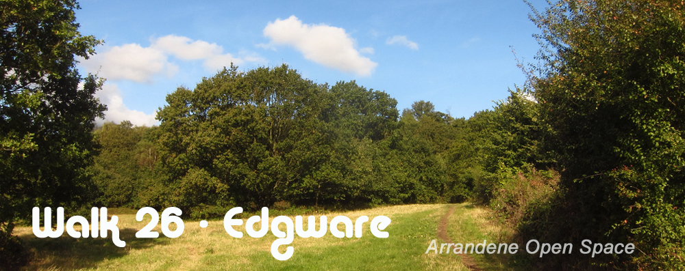
Walk 26 -
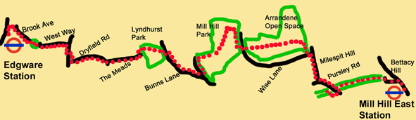
From Edgware Tube Station, at the Northern End of the Northern to Mill Hill East via Mill Hill Park and Arrandene Open Space
|
Distance |
6.5 Km (4 miles) |
|
Underfoot |
Mostly surfaced paths |
|
Outward Journey |
Northern Line To Edgware , About 30 minutes from Central London |
|
Return |
By Northern Line from Mill Hill East |
|
Points of Interest |
Mill Hill Park, Arrandene Open Space, Mill Hill Old Railway Nature
Reserve (open Saturday/Sunday)
|
|
Refreshments |
Cafes at Edgware, Shops and Takeaway Fish and Chip Shop in Pursley Road |
|
Public Toilets |
Toilets in the Shopping Centre adjacent to Edgware Station |
|
Shortening the Walk |
No options |
What To Expect from This Walk
This walk involves a fair amount of street walking but also several green open spaces, particularly Mill Hill Park and Arrandene Open Space. It meanders its way eastwards from Edgware to Mill Hill East and concludes with an unusual stretch along a disused railway line.
Route Directions

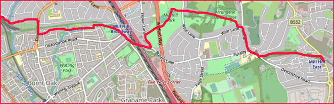
1. After passing the ticket barriers at Edgware Underground Station, cross over the station approach and turn right on the main road (Station Road). After 60m, another right turn takes you into Bakery Path, which you follow to Brook Avenue. Turn right and walk to the end of the road. Enter a small park and cross a bridge over Deans Brook. Leave the park and reach the corner of Farm Road and West Way. Go straight ahead up West Way to a T-junction and take a right turn into Deans Lane.
2. Walk to the pedestrian lights, cross to the opposite footway and continue in the same direction as before. Take a path to the left which drops down below the level of the road to the entrance of Mill Hill Old Railway Nature Reserve. There are two options here.
If the nature reserve is open
Pass through the gate and follow the path for 900m. Exit through another gate and turn immediately right. You will find a small water course (Burnt Oak Brook) blocking your route but turn left on a faint path for 100m and then go right over a bridge to reach Lyndhurst Park. Turn left on a path which you follow through the park and then exit via steps into Bunns Lane.
If the nature reserve is closed
Continue up the footpath past the entrance gate and take the first road on the left (Dryfield Road). After 450m reach a green on your right and turn left to enter The Meads, which runs parallel to Burnt Oak Brook. Continue to the end of this road and enter Lyndhurst Park through a gate in the left-hand corner, beside some houses. Follow the path through the park and then exit via steps into Bunns Lane.
3. Turn right on Bunns Lane and cross to the left-hand footway. Walk past a roundabout and continue along the left- hand footway. Follow the road as it takes you left under a railway line and the M1 motorway. Continue until you reach Flower Lane, with Mill Hill Park in view. Cross Flower Lane and turn left on the pavement along the edge of the park. From here you can either keep to the pavement along the park perimeter and then turn right into the park on a surfaced path, or you can take a short-cut diagonally across the grass (towards a dead tree) to join the same path.
4. Follow the path and go through an underpass into another section of Mill Hill Park. Continue ahead, passing some tennis courts. Just before reaching a vehicle barrier, turn right onto a smaller path. Follow this path as it turns left and right around a hedge. 200m later turn left to leave the park through a gate into Wise Lane. Turn right and walk for 25m. Cross the road and go through a gate set in the hedge into Arrandene Open Space. Continue ahead uphill on a grassy path.
 5. At the top, ignore a crossing path and go ahead to the right of some trees, across the open space, to reach a broad woodland track in the bottom right-hand corner. This track leads you uphill to an open meadow with good views ahead. Ignore a path which goes to the left alongside the wood. Instead, take the broad grassy track which descends down the middle. The track passes through a belt of trees to reach a smaller meadow. Go ahead across this meadow and pass through another small group of trees. Continue downhill to a junction with a larger path, on which you turn right to reach a gate into Wise Lane. Turn left, cross the road and walk diagonally right across an area of grass to reach Milespit Hill.
6. Turn right, walk to the end of Milespit Hill and turn left into Pursley Road. After 100m you pass a small convenience store and a takeaway café on the left. Cross the road to the right-hand footway and go ahead over a bridge. At the far side of the bridge, turn right and go down the steps immediately beside the bridge parapet. At the bottom, turn right on a disused railway line and follow it underneath the road bridge you have just walked over.
7. Continue for 400m, then pass under another bridge and go through a metal field gate, with houses ahead. Walk through an alleyway leading between the houses and continue until you reach a minor road (Bettacy Road). Turn right and follow the road as it swings left to join a main road (Bettacy Hill). Turn right to reach Mill Hill East Station.


- Details
- Hits: 8542
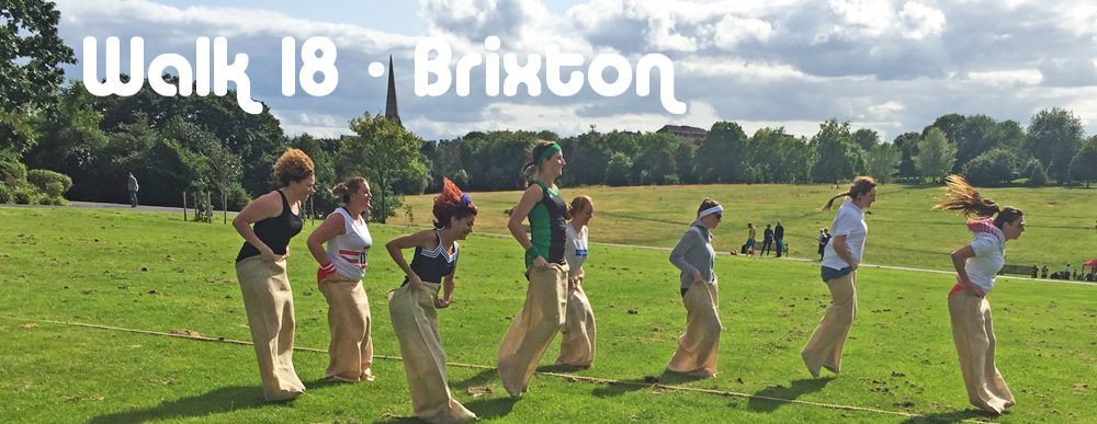
Walk 25 - From Brixton Tube Station, at the Southern End of the Victoria Line to Herne Hill via Brixton Windmill and Brockwell Park
|
Distance |
6 kms (4 miles) |
|
Underfoot |
Paved or solid pathways throughout |
|
Outward Journey |
By Victoria Line to Brixton - about 10 minutes from Central London |
|
Return |
By train from Herne Hill to Victoria or bus back to Brixton |
|
Points of Interest |
Brixton Windmill, Brockwell Park |
|
Refreshments |
Cafes and pubs in Brixton, Cafe in Brockwell Park |
|
Public Toilets |
Brixton Library and Brockwell Park |
|
Shortening the Walk |
Bus stops en route to return to Brixton |
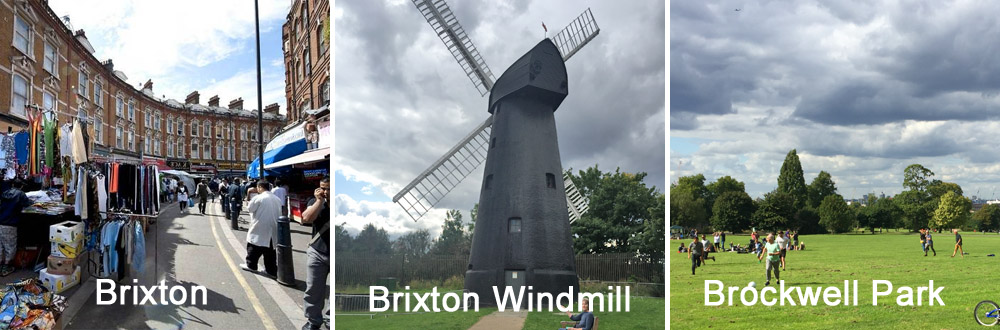
What to Expect From This Walk Tube lines in south london do not extend to open countryside. So, this is a deeply urban walk but it has some enjoyable features, not least, a surprising windmill and a lovely open stretch of land in the form of Brockwell Park. Some of the connnecting roads are quiet and leafy, The park has lots of interesting features including gardens & lakes and a cafe where you can have refreshments. On a sunny day it is full of people doing recreational things like cycling, playing football and even taking part in a a sack race.
Route Directions
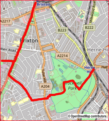
1. Turn left when you come out of Brixton Station. Go straight over the major road junction with Coldharbour Lane (A2217) and arrive at Windrush Square. Turn right and cross Effra Road to reach St Matthew’s Gardens, a triangle of land formed by the junction of Effra Road and Brixton Hill (the A23). Walk along the left-hand footway of Brixton Hill, keeping to the right of St Matthew’s church.
2. Pass Brixton Orchard and carry on walking through Rush Common, a green area which runs parallel to the road, separating you from the traffic for a few hundred metres. Where this green stretch finishes at Brixton Water Lane, you need to rejoin the footway on Brixton Hill. At the next set of pedestrian lights, cross to the other side of Brixton Hill. Continue in the same direction and then turn right into Blenheim Gardens. Walk to the end of this short road, past the Windmill music venue and pub, and enter Windmill Gardens to see Brixton Windmill.
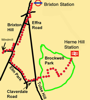
3. After your visit to the windmill, retrace your steps to Brixton Hill. Cross to the opposite side, turn right and walk up the left-hand foot-way. Turn left into Elm Park, the fourth road on the left, and walk down this quiet street for 400m. At the junction with Claverdale Road, turn left and go on to reach Tulse Hill (the A204). Cross over and enter the pathway between houses to the right of a petrol station. The path turns left, right, and then left and right again to reach Brockwell Park. You can follow almost any route to explore the park (see the plan on p.92). What follows here is therefore only one of the options.
4. Go ahead across a grassy path and turn left around a hedge. Enjoy a visit to the walled garden ahead on your right and then walk past the pond on your left. Go right at the community greenhouses, pass between tennis courts and turn right again to reach an area of grass. Walk across the grass towards Brockwell Hall, which has a café with indoor and outdoor seating at the back of the building. To continue the walk, go back to the front of Brockwell Hall. With the imposing pillars of the front entrance behind you, turn right and make your way downhill. You are aiming for the Herne Hill exit of the park. From here you can either get a bus back to Brixton or take a train to London from Herne Hill Station in Railton Road.
Information on Things You Will See
Brixton is a district of London, within the Borough of Lambeth. It is mainly residential with a substantial retail sector. It is a multiethnic community, with a large part of its population being of Caribbean descent. Brixton has a vibrant atmosphere with a busy street market and a thriving art scene. The area is slowly moving up-market with many middle class families moving in to take advantage of its central location and good communications.
Brixton Windmill is a Grade II listed building and is a significant reminder of Lambeth’s rural past. It is the only remaining windmill in central London. It was built in 1816 on part of Stockwell Manor. Until the middle of the 19th century Brixton remained largely undeveloped and was agricultural in character. The windmill is constructed from brick and wood but has been paint.ed with black tar, a traditional method of weather-proofing. It is 15 metres tall and at the top, there is a wooden cap which can be turned so that the sails always face the wind.The sails originally turned a series of cogs which powered a millstone on the second floor. There is a record of a John Ashby of Brixton Hill obtaining a 99-year lease in 1817 for two acres of land to the south of a new road to be called Cornwall Road (now Blenheim Gardens), together with a ‘brick corn mill’ and other buildings. The windmill was soon surrounded by outbuildings, which included a mill cottage and a bakehouse, where bread was baked and sold to local people. In 1957, the London County Council (LCC) bought the land, the windmill and the associated buildings and decided to turn the 2.5 acres of land into a public open space - Windmill Gardens.
Brockwell Park consists of 125 acres of open land and commands views of the skyline of Central London. Brockwell Lido is a Grade II listed art deco building. It is an open air swimming pool with an attached café/restaurant. Other amenities in the park include gardens, tennis courts, a bowling green, a BMX track and a miniature railway. The park is home to the Lambeth Country Show which usually takes place in July. Also, an annual fireworks display takes place around November 5.
- Details
- Hits: 10240
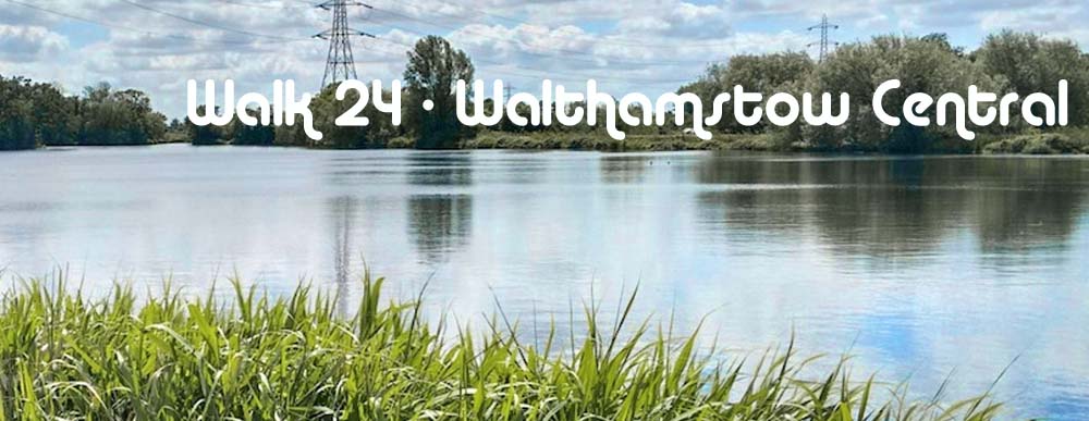
Walk 24 - From Walthamstow Central, at the Northern End of the Victoria Line to Tottenham Hale via Walthamstow Wetlands
|
Distance |
9.5 km (6 miles) |
|
Underfoot |
Paved or solid pathways. No mud |
|
Outward Journey |
By Victoria Line to Walthamstow Central - about 25 minutes from Central London |
|
Return |
By Victoria Line or train from Tottenham Hale |
|
Points of Interest |
Walthamstow High Street, Walthamstow Wetlands, River Lee |
|
Refreshments |
Cafes and pubs in Walthamstow, Wetlands Visitor Centre, Ferry Boat Inn |
|
Public Toilets |
Walthamstow Central Station, Visitor Centre in Walthamstow Wetlands |
|
Shortening the Walk |
From the Visitor Centre walk directly to Tottenham Hale Station |
PLEASE NOTE : Dogs are not permitted in Walthamstow Wetlands
What To Expect From This Walk
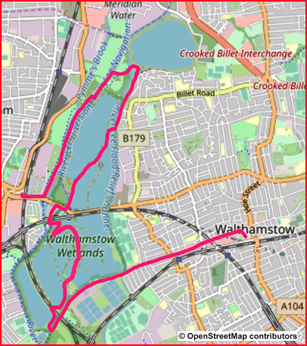
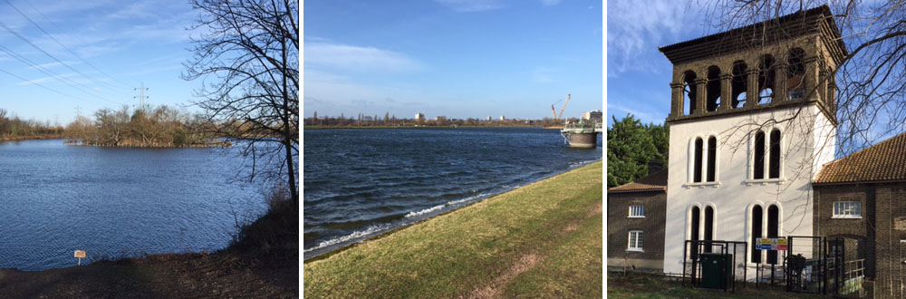
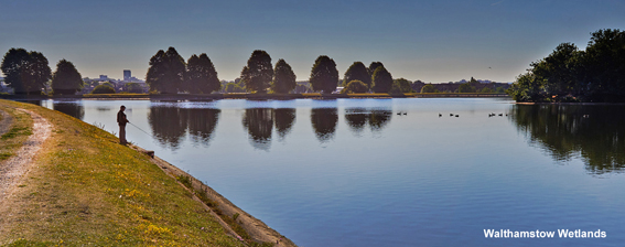
The walk starts by visiting one of the most colourful high streets in London. Walthamstow High Street is home to a host of individually owned shops and market stalls with a wide ethnic mix. Walking down this pedestrian area is a feast of sights and sounds. After the High Street, the walk continues down Coppermill Lane which then becomes more scenic. However, it is not until roughly the 3Km mark that you enter Walthamstow Wetlands. It is well worth the wait. The many reservoirs make walking an interesting project and there are wide views from horizon to horizon. After a couple of kilometers you reach the visitor center which is housed in The Old Engine House with refreshments available. After this you enter the second section of the Wetlands. The reservoirs in this section are at two different levels and your walk takes you along the bank of the higher reservoir with more good views all around. Leaving the Wetlands, the walk goes north and then east to join up with the River Lea Navigation. Turning south, a 2 Kilometer stretch of towpath walking brings you back to Tottenham Hale tube station.
Route Directions
1. At the top of the escalator at Walthamstow Central Station, turn left up some steps, following the signs to Selborne Road. You come out into Walthamstow bus station. Turn left here and cross the road to an open green area. Turn half-right and walk across the green to Walthamstow High Street, which you can see ahead. Turn left and walk down the High Street. This is your direction of travel for the next 3 km.
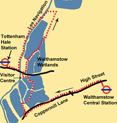
2. Cross Willow Walk and later cross St James Street to enter Coppermill Lane. After another 1 km the road narrows and the view opens out on both sides. You can see a reservoir on your right and a Thames Water treatment plant on your left. Continue ahead for another 850m. After a bend in the road, turn right to enter Walthamstow Wetlands. Follow the path right and go past the Coppermill Tower. Continue for another 150m and then turn sharply right over a concrete bridge. At the end of the bridge, turn back left into an open space and look for a pathway going to the right. Go through a gate and swing left on an attractive path with water on both sides. Continue between the reservoirs for over 1 km until you come to a green fence with a railway line and road beyond.
3. Turn left on a track. You soon reach the Wetlands Visitor Centre, which has a café. Exit the visitor centre from the side opposite to the one you came in by. Walk through a car park to reach Forest Road. The Ferry Boat Inn is straight ahead. Cross the road, turn right for 50m and then turn left to enter a second area of wetlands. Swing left with the pathway and continue for about 250m until the embankment of a reservoir appears on your left. Turn left and climb the steps up to the level of the reservoir. Turn right and walk alongside the water with good views all around. After 750m you meet a fence which crosses the path and runs down the bank on your right. Leave the path here and go carefully down the grass bank beside the fence. There are no steps but the descent is not difficult.
4. At the bottom, go ahead on a path which turns left and then right to cross a bridge. This is where you leave the Walthamstow Wetlands. Take a narrow pathway to the left and follow it with a watercourse on your left. When the path reaches a housing estate, follow a signpost ahead for the Lee Navigation. At the next signpost, turn left towards Tottenham Marshes. After 200m you cross a bridge and arrive at a visitor information board welcoming you to the Lee Valley. Walk past the board and go slightly to the left on a path which crosses open grassland. Go over a green bridge and reach the towpath of the Lee Navigation.
5. Turn left and walk to a set of locks. Stay on the towpath as it crosses to the opposite bank and continue in the same direction down the river for another kilometre to reach Forest Road (A503) at Tottenham Hale. Turn right to reach Tottenham Hale Underground Station (Victoria Line) and the adjacent mainline station with trains to Liverpool Street.
Information On The Things You Will See
Walthamstow Wetlands Is a nature reserve extending over 500 acres in north east London. It was created from the area known as Walthamstow Reservoirs managed and is owned and managed by Thames water. It is particularly important for birds and wildfowl due to its position in the Lee Valley which is a green corridor through the heart of London. It is one of the largest urban wetland nature reserves in Europe. Visitors can freely access the site’s natural, industrial and social heritage in one of the capital’s most densely populated urban areas. The project was made possible after the Heritage Lottery Fund provided £4 million in funding.
The Coppermill Tower or Building is Grade II Listed and has undergone a number of alterations over the centuries, including the addition of an Italianate tower in 1864. The previous mill on the site has been mentioned several times throughout historical records. It was noted that in the 14th century, the mill was powered by the Coppermill Stream that diverted from the River Lee for use in grinding corn.
The River Lee (or Lea) is a tributary of the River Thames which rises in the Chiltern Hills and runs for 90Km (56m) to enter the Thames at Bow Creek. The river is canalised for most of its length and historically has always been a major trading route. However, commercial traffic effectively ended in the 1980s and it is now recreational.
- Details
- Hits: 10285
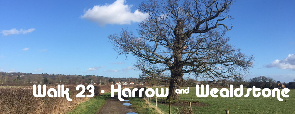
Walk No 23 – from Harrow & Wealdstone, at the northern end of the Bakerloo Line, to Stanmore
|
Distance |
14.5 Km (9 miles) |
|
Underfoot |
Roads and country paths. Muddy after rain |
|
Outward Journey |
Bakerloo Line to Harrow & Wealdstone (about 40 minutes from Central London) |
|
Return |
By Jubilee Line |
|
Points of Interest |
Harrow Museum, Bentley Priory Park, Stanmore Hill |
|
Refreshments |
Moat Visitor Centre Cafe, The Case is Altered PH at Old Redding |
|
Public Toilets |
Toilets at the Moat Visitor Centre |
|
Shortening the Walk |
From Bentley Priory Park (Point A) you can walk directly to Stanmore |
What To Expect From This Walk
The first half of this walk involves a number of suburban roads but the second half is entirely "green" with a nice mixture of fields, woods and parkland culminating in a visit to one of he highest viewpoints in London. Be prepared for mud underfoot especially in winter. Harrow Museum and the Moat Visitor Centre is the first real point of interest but this is soon followed by a lovely long distance view of the route ahead. At Old Redding the walk joins the London Loop and follows it to Bentley Priory and Stanmore Country Park. Walking is mostly easy with a couple of steady climbs and a final ascent of Stanmore Hill.
Route Directions
1. At Harrow & Wealdstone Station take the exit at platform level from Platform 1. Walk across a car park, turn right, away from the town centre, and follow the road left into Kings Way. Walk to the end, turn left into Queens Walk and then right into Marlborough Hill. In 200m, just after Marlborough Primary School, turn right into a passageway between houses. Go across Walton Drive and continue along a passageway to Harley Crescent, where you turn left. At the next junction turn right onto Harrow View and then go immediately left onto Hide Road.
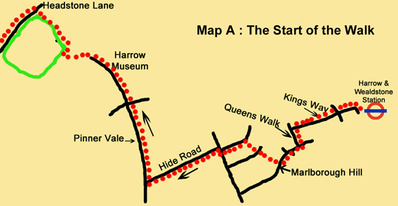
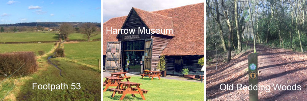
2. Follow this road until it reaches a T-junction, with a church on your left. Turn right on Pinner Vale and walk downhill to a main road. Cross at the pedestrian crossing and go straight ahead along the continuation of Pinner Vale to reach Harrow Museum and Heritage Centre. On your left is the Moat Café Visitor Centre (closed Mondays). Walk past the visitor centre and enter a park. Turn right and follow a broad path out to the main road (Headstone Lane). Turn left, cross the road and walk for 400m to take the third road on the right, Elmcroft Crescent. Follow this as it turns left and arrives at George V Avenue. Cross over and enter a footpath signposted to Pinner Village. Follow the path for 250m to meet Wakehams Hill and go ahead for another 250m to find a path on your right, signed Footpath 53. As you join this footpath, there is a broad view of your route ahead, across the valley towards Stanmore Hill. The path then descends between fields for 550m and meets George V Avenue again.
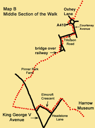
3. Cross over and continue ahead on a bridleway past Pinner Park Farm. Walk for another 500m between fields to reach a narrow lane. Cross the lane into the small footpath opposite, between a gated drive and a metal fence. After 100m the path leads to a footbridge over a railway line. Cross the bridge and turn into Letchford Terrace, the second road on the left. You reach a main road (Headstone Lane). Turn left here, take the first road on the right (Tillotson Road) and walk to the end to meet Courtenay Avenue, another main road. Turn left along the left-hand footway and walk to a roundabout. Your onward path starts from the opposite side. To reach it, go left to cross the A410 at the pedestrian lights, then cross Oxhey Lane (the A4008). Continue clockwise round the roundabout, but before reaching the next exit, turn left into an enclosed path and walk uphill. After 550m you come to a wooden fence across the path. Go left for a few steps around the fence to enter a field and continue along the right-hand edge of the field for another 500m. You eventually come out onto an unsurfaced lane between houses. Turn left for 20m and then turn right to follow the lane out to a road beside a pub (The Case is Altered). Turn right, then after 50m go left to cross the road and follow a London Loop waymark into woods.
4. Arrive at a junction of paths with houses ahead. Do not turn right here but continue ahead to reach a lane beside the houses. Turn right along the lane and where it finishes at the last house, go ahead on a footpath, with the edge of the wood on your left, and follow a series of yellow waymarks to Bentley Priory. Continue over a number of footbridges and boardwalks, looking out for a post indicating where your route turns right. Turn right, and follow the path for 200m to go up some steps and reach a road. Cross to a gate directly opposite and enter the Bentley Priory Nature Reserve.
5. Walk on for 300m and go through another gate. Turn left and walk along a paved footpath for 750m to a junction of paths, signposted Stanmore Hill to the left and Stanmore Church to the right. This is point A where you can shorten the walk – see directions at the end.
6. To continue, turn left and go through a gate to leave the grounds of Bentley Priory. Follow a track out to a road lined with large houses and turn right. After 100m turn left along Priory Drive. Cross the A4140 to enter Warren Lane. Walk for about 100m until you see a car park on the left. Enter the car park and go to the far right-hand corner. Follow the London Loop signs into the woods, along a narrow path which twists and turns before joining Warren Lane again. Take the path opposite, following the London Loop signs, which lead you between several ponds. Turn left behind some houses, with a wooden fence on your right. Reach a grassy area in front of some cottages. Walk to the bottom left-hand corner of the grassy area and turn left into the woods towards a large pond with a low fence. Walk with the pond on your right and reach a road. Cross the road and turn right, walk for 100m and turn left onto Dennis Lane.
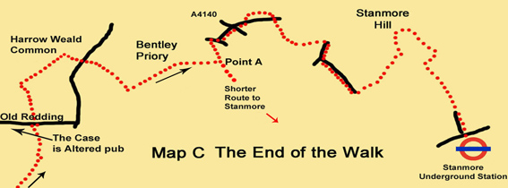
7. Walk downhill for about 250m and turn left through a gate (with a London Loop waymark) into Stanmore Country Park. Go ahead for 100m to reach a grassy clearing. At this point, you leave the London Loop. Turn left, as indicated by a Nature Trail (NT) signpost. Pass Post 9 to follow a path downhill through trees. At Post 10 you carry on downhill. When you reach Post 11, leave the nature trail, go ahead, cross a bridge and emerge from the woods to climb some steps up a grassy bank. Take the left-hand path uphill to climb to the top of Stanmore Hill, ignoring any turnings left or right. When you reach the summit with its benches and a panorama board, take some time to admire the views across London. Your onward path is downhill to the left as you face the panorama board. At a fork, take the right-hand path, which swings right and begins to contour along the hillside. Look out for a fence with wooden posts below you and to the left. Take a narrow path which leads down to the corner of the fence and follow it around the fence corner to reach a large post with waymarks. From here your route is ahead (south) downhill. Pass a bench and go through a gate into the woods. Continue downhill for about 300m in this direction and then leave Stanmore Country Park through a gate. Walk down Kerry Avenue to reach Stanmore Station.
To shorten the walk from Point A
Turn right towards Stanmore Church. Follow this well-surfaced path for 1 km, past a deer park. When you reach some open land, continue ahead and leave the park to go down Old Lodge Way, the residential road directly ahead of you. Follow this road to the T-junction with the A410 (Uxbridge Road). Turn left and walk 1.5 km to Stanmore Station via the town centre or take the H12 bus
Information on Things You Will See
Harrow Museum known as Headstone Manor & Museum, is the local history museum for the Borough of Harrow. It was established in 1986 and consists of four historic buildings. The Manor House is one of the earliest surviving timber framed building in London. Built in 1310, it is surrounded by the only surviving filled moat in Middlesex. The moat is as old as the oldest part of the building, and was probably constructed as a status symbol to reflect the wealth of the Manor’s owner. Other buildings on the site are The Great Barn, The Small Barn and The Granary.
Stanmore Hill is one the highest viewpoints in London rising to 152m (500feet) On a clear day you will see for 20 miles and the view easily takes in such landmarks as Canary Wharf, The Shard. The Gherkin and Wembley Stadium.
The London Loop is a 240Km (150mile) long distance circular path around London which runs mostly within the M25 Motorway. Its 24 sections make maximum use of London’s open spaces and parks.